Newsletter Spring 2022

Spring 2022
Newsletter
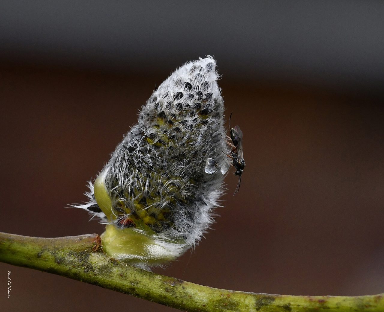
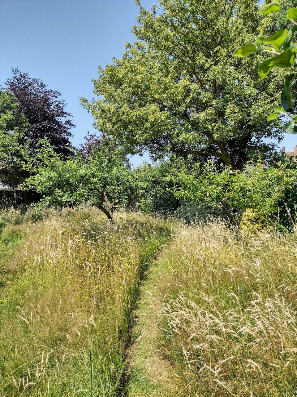
Pussy Willow and wasp
with thanks to Paul Kitchener
SBIS News
New team members: Last year we were delighted to welcome two new team members. Hannah Alred is our new Ancient Woodland Inventory Officer and is responsible for creating the new Suffolk Ancient Woodland Inventory. Emma Aldous is our new Communications Officer and is responsible for looking after our website, social media, our newsletters and more!
Our database has grown and now holds over 5 million records!
Projects
Lidar derived tree canopy polygon data
Data from NCC is being analysed and we now have tree canopy cover figures for all Suffolk parishes. We are currently working on producing separate figures for woodland and non-woodland, and conifer and broadleaf, using OS MasterMap and Forestry Commission data. Once this is complete analysis to classify hedgerows by gappiness and average height will follow.
Land Cover Map 2020 raster data
This free 25m raster data has been downloaded, mapped and made available internally in GIS. 10m resolution data is also being imported. The data from these will help target action to increase biodiversity.
Supporting Partners
Orchards East
The final version of the Orchards East dataset, with GIS polygons and text for each orchard, was received from Tom Williamson at the University of East Anglia. It incorporates data from the earlier project by Suffolk Traditional Orchards Group (STOG). The data will be available to partners via our download page (Users need to register by contacting SBIS to gain access to the relevant download section). We now attend meetings of the volunteer legacy organisation, Orchards East Forum, in rotation with representatives from other Local Environmental Records Centres. For more information about the work they do visit: www.orchardseastforum.org
Ancient Woodland Inventory update
Working with Natural England, the Suffolk update is now well underway, with all necessary data imported and processed. See our full report on the progress of the current phase and outlines of the future phases of the Ancient Woodland Inventory project.
Native Black Poplar
We are working with Sue Hooton (Native Black Poplar recorder) to create an online map, verification and recording portal on the SBIS website for the Suffolk Tree Warden Network and surveyors.
County Wildlife Sites and Roadside Nature Reserves
Suffolk Wildlife Trust are continuing to re-write many CWS citations which we are incorporating into our database. Maintenance of the CWS and RNR GIS datasets continues but there have been no major changes over the past few years.
GIS biodiversity data updates are made available twice yearly for download by partners (notified by email) from www.suffolkbis.org.uk/downloads. Users need to register by contacting SBIS to gain access to the relevant download section where partners can download the full update of Species, Sites and Orchards East boundaries (in 2 formats: MapInfo TAB or ESRI Shapefile with site citations in Access, Excel or PDF format), or just the County Wildlife Site, Roadside Nature Reserve and County GeoSite update.
Commercial Data Enquiries
Over the last year we have seen a 26% increase in commercial data enquiries, from 509 in 2020 to 643 in 2021. This resulted in a 27% increase in species records being sent to ecological consultants, from 476,559 in 2020 to 607,384 in 2021. We also saw a 32% increase in cross-boundary searches shared with neighbouring record centres, from 37 in 2020 to 49 in 2021.
Percentage change from 2020 to 2021
Surveying our Geological SSSIs
Caroline Markham, GeoSuffolk
Over the last two years GeoSuffolk has been contracted by the Geology Trust to survey some of Suffolk’s geological SSSIs for Natural England. So far, we have surveyed seventeen – eleven of these designated for exposures of Pliocene Coralline and Red Crags and six for younger Pleistocene deposits. This work is done in winter – to minimise disturbance to wildlife, also because there is less vegetation obscuring the geological exposures. We have been most fortunate to have access to these geosites during the variety of lockdown conditions of the last two winters – fascinating geology and work in the open air!
This was an easy and enjoyable task in many of the disused crag pits, most of which are in good condition. Buckanay Farm pit SSSI in Alderton for example is one of those Suffolk Red Crag pits which open up in quite an astonishing way from relatively flat ground. It displays a variety of sedimentary structures plus an almost bewildering array of fragmented fossil molluscs. It is on private land but can be glimpsed from the footpath between Alderton and Shingle Street as in the photo, taken when we did the survey in December 2020.
Rockhall Wood pit SSSI in Sutton, whist being enjoyable was far from simple. To do justice to the citation, which finished with ‘In the study of Pliocene geology this is probably the most important site in Britain’, we took 50+ photographs all of which had to be described and given eight-figure grid references. Fortunately, we are familiar with this site as GeoSuffolk has done much site management here in the past. It is still in very good condition. showing its almost complete Coralline Crag stratigraphy right up to the unconformity with the Red Crag. It is a large site comprising an outlier of Coralline Crag with quarries on three sides - the photo was taken when we did the survey in February 2022 and shows the north face exposure of Coralline Crag, which is may be seen from the footpath (with two people walking on it).
Geological SSSIs are designated for their research interest and our (geologically) young deposits in Suffolk have generated much interest lately due to their relevance to climate change. GeoSuffolk’s job was to assess the quality and accessibility of the exposures for future research. We had the citation for their designation from the NE website, naturalengland.org.uk, arranged a site visit with the landowner and made a photographic record of the features in the citation that we could find on site plus any new features of interest. We also assessed constraints to study – vegetation and talus build-up in particular and made recommendations on their future management to Natural England.
Buckanay Farm pit SSSI
You would think, having visited it in summer 2018 that we would be familiar with details of the Red Crag exposures in Bawdsey Cliff SSSI. However, in January 2022 they were unrecognisable, such was the erosion over the intervening 3+ years. The Red Crag sedimentary structures and fossils in the citation are still visible, but the beach has been lowered such that the unconformity with the London Clay is now generally 3-4 metres above the beach.
Rockhall Wood Pit SSSI
This renders the Red Crag inaccessible high up in the cliff – as in the photograph taken on our survey. The geology of the SSSI received a good report from us but we advised NE that access along the shore could soon become difficult from both north and south because of beach lowering. We only had 1½ hours either side of low tide to complete our survey. it was a fabulous walk and we saw not another soul save our four GeoSuffolk companions but thank goodness for the wonderful January weather this year!
Last year it was not so good, and snow dogged our attempts to survey our final site of 2021. Stoke Tunnel Cutting in Ipswich is designated to protect the interglacial lake bed deposits discovered when the railway tunnel was dug in the 1840s. These have been dated at approx. 210,000 years old and have yielded a variety of vertebrate fossils. The railway line splits the site in three, only one of which, a protected open space in a residential development, was easy to access.
Bawdsey Cliff SSSI
On the other side of the railway line the SSSI lies within Hillside School grounds, so we had to wait till the end of the winter 2021 lockdown – and then it snowed! We did get there in the end, but as for the railway cutting itself, Network Rail were very accommodating and said we could visit it between 01.30 and 04.00! We opted for photos (in daylight) from an access gate close to the tunnel. The photo shows GeoSuffolk’s interpretation panel at Worsdell Close, the grassed area protects the Pleistocene deposit – a lake bed is a finite resource, so not to be exposed unless necessary. Hillside school is in the background (across the railway line) and in the distance to the right the houses on top of the railway bridge can be seen.
Stoke Tunnel Cutting SSSI
An update on river habitat enhancement work
Naomi Boyle, Environment Agency
River Deben, VeloWibble/Flickr
The Environment Agency ‘Environment Programme Team’ has been working with partners at Essex & Suffolk Rivers Trust and the River Waveney Trust to deliver river habitat enhancements.
These improvements are required to help our rivers achieve ‘good’ status under the Water Framework Directive. This work has been funded through Defra’s Water Environment Improvement Fund.
Works being carried out this winter include a cattle crossing on the River Alde to reduce sediment entering the river, brushwood bundles and the creation of a marginal bay on the Earl Soham watercourse to increase flow and habitat diversity as well as a floodplain scrape. In addition to this over 500 native trees and scrub have been planted alongside the Rivers Alde, Ore, Deben, Waveney, Dove and the Earl Soham watercourse. These will not only provide habitat enhancement but will help to keep our rivers cool, provide bank stability and a buffer to any nutrient and sediment enriched runoff entering these rivers.
River Waveney at Homersfield with the River Waveney Trust
River Ore at Parham with Essex & Suffolk Rivers Trust
Urban Greening
in Felixstowe
Dr Adrian Cooper
Urban greening is a process of increasing the amount of land given over to trees and plants which help local wildlife. Ideally, urban greening involves planting designated areas of land with new trees and other plants. However, it may also be developed where pioneer individuals and groups start to grow new wildlife-friendly plants in small urban spaces. When others join in those initiatives, green corridors may develop. Then green networks may follow on.
In the Felixstowe area, we have successfully developed our urban greening project since May 2015. We call it Felixstowe’s Community Nature Reserve (FCNR). It was begun as an attempt to stop the decline in local wildlife populations. FCNR has three aims which may be summarized as follows:
- To educate local people about the decline in local wildlife, and what each local person can do to stop that decline.
- To start growing new trees and plants within at least 3 square yards of their back gardens, or allotments. Additional examples of wildlife-friendly activity include re-wilding of at least 10% of garden / allotment areas, and the building of wildlife ponds, hedgehog homes and tunnels, and insect lodges.
- To help and encourage as many others as possible with these activities.
For local people who live in flats, FCNR recommends that they take part in this work by growing plants such as herbs and roses in pots on their balcony.
At the time of writing, FCNR has just over 1,700 active members. The average allocation of space for wildlife-friendly activity is 3.65 square yards. Collectively, this means that FCNR has the area of a full-sized football pitch.
In May 2020, the Felixstowe Citizen Science Group conducted an Impact Analysis on the work of FCNR. The analysis sampled the experience of improved biodiversity within the gardens of 100 members of the Community Nature Reserve. The survey showed that 62% of people in that sample found an increase in the biodiversity in their gardens since they became members of FCNR. The survey also found that 68% of surveyed members grow at least one of the plants recommended by FCNR in their Facebook page. Equally, 66% of people in the survey grow plants which are targeted at helping local bees. A full version of this impact analysis can be found on the Community Nature YouTube channel under the title of Impact Analysis 2020.
In the first few months of 2021, the RSPB published a feature on FCNR in their Nature’s Home magazine: a publication which is distributed to 400,000 RSPB members. That publication helped with the diffusion of FCNR’s ideas. At the time of writing, there are ten other groups across the UK which have adopted and adapted the urban greening ideas of FCNR. They are:
- Ipswich Community Nature Reserve
- Transition Woodbridge
- Bredfield Wildlife-Friendly Village
- Newmarket Community Nature Reserve
- Brightlingsea Nature Network
- Burton Latimer Community Nature Reserve
- Calne Community Nature Reserve
- Hitchin Nature Network
- Cosby Community Nature Reserve
- Hadleigh Environment Action Team
In addition, FCNR has influenced the establishment of the Pontos and Vida conservation project in Portugal.
To further develop their work, FCNR appointed a Schools Ambassador in the summer of 2021 to promote urban greening among local school children. That promotional work included the start of a Wildlife Writing, Photography and Art competition. An early product of that initiative led to some local school children’s creative writing being read out on the Felixstowe Radio station. Other targeted projects with local children are planned for 2022.
FCNR has also started to encourage local business people to plant trees within the grounds of their organizations, and to also grow more trees in their home gardens. In return, FCNR publicizes those businesses as a sign of appreciation for that work.
Despite the encouraging results of this work, FCNR members still encounter cynicism from a few local people. Those cynics sometimes ask why it is necessary for an independent voluntary group, such as FCNR, to do this work. The reply, quite simply, is that no other organization is doing this kind of grass-roots environmental work in our area. Other cynics question why any example of urban greening matters. In reply, members explain that the community nature reserve offers a legacy to the local area which will benefit the children, grandchildren, nieces and nephews of all local people.
As an organization, FCNR encourages local people to feel empowered to start and develop new projects without the need to discuss those plans with any centralized leadership. This decentralized form of power helps to make the community nature reserve as sustainable as possible. Examples of those micro-level projects include plant swapping, garden pot swapping and even garden cane swapping. It also includes examples of assistance, advice and support between members. In this way, FCNR can be thought of as a multi-project environment. That is, within the overall FCNR project, there is a myriad of micro projects being developed in ways which suit local members.
Felixstowe’s Citizen Science Group was established in April 2018 to quantify and analyze the work of FCNR. In addition to the Impact Analysis discussed above, the local citizen scientists try to complete at least one new project each month. The results of that work may be viewed on the Felixstowe Citizen Science Group Facebook page.
A major part of the innovation process for FCNR arises through their membership of the National Biodiversity Network: the UK’s largest network of conservation groups. Felixstowe’s Citizen Science Group is also a Network Supporter of the European Citizen Science Association. In this way, new ideas from a wide catchment area are drawn into local work in the Felixstowe area.
The main conclusion to be drawn from this discussion is that FCNR has established an approach to urban greening which appears to be successful and sustainable. While there is no room for complacency, there is a place for hope within the future strategies of urban greening in the UK and beyond. Encouraging youth participation will be essential to that work.
Footprints
East Suffolk Council’s
conservation volunteering scheme
Daniel Wareing,
East Suffolk Council
Melton Picnic Site
East Suffolk Council’s Countryside Team are on the lookout for volunteers seeking opportunities to do their bit for nature in East Suffolk by helping manage East Suffolk Council’s countryside sites.
Upper Hollesley Common
Where can I volunteer with Footprints?
We’re on the lookout for volunteers who would be able to help out at the following sites:
- Woods Meadow, Oulton Broad
- Sutton Heath and Upper Hollesley Common
- The Grove, Felixstowe
- Melton Riverside
- Bawdsey Picnic Site
- Leeks Hill, Melton
- Farthing Wood, Kesgrave
- Mill Stream and Sandlings, Rushmere St Andrews
- Brook Farm Wood, Saxmundham September
- Sizewell beach and car park
- Nacton Shore
The Countryside team organises regular “work parties” for teams of Footprints volunteers to carry out a particular task at our countryside sites, with examples of tasks including the following:
- Heathland management and reclamation, felling, coppicing and control of invasive species – autumn/winter.
- Woodland management – autumn/winter.
- Hedge maintenance – autumn/winter.
- Ditch and pond maintenance – autumn/winter.
- Litter picking and site clean ups – any time of year.
- Plant and animal surveys – spring /summer
- Footpath improvements - any time of year.
- Hay raking - summer
- Planting trees and hedgerows
- Reporting any issues back to the Ranger
- Fence repairs and other infrastructure
- Help in running small events and guided ‘walks and talks’
Woods Meadow, Oulton Broad
What support do Footprints volunteers get?
The Countryside Ranger will provide training on the safe use of tools and will demonstrate how to tackle the tasks that the work party will undertake before work starts. All tools required for the task are provided by the Countryside Team.
While you are volunteering on behalf of the Countryside Team you are covered for personal accident and public liability insurance, until you are 75 years old. The Countryside Team do a risk assessment for each activity.
I’m a young person, can I get involved?
Children (8-16years old) and young persons (16-18years old) with additional needs can attend work parties, but they must be accompanied and supervised by a responsible adult and be there with the permission of their parents or carers. The countryside team are DBS checked.
Can I bring colleagues from my workplace?
Yes – if you’d like to arrange for a team of your colleagues to join us on a work party, whether as a positive team-building exercise or as part of your Corporate Environmental and Social Responsibility Policy, we’d be pleased to organise an activity for you.
How do I register?
If you like the outdoors and nature and want to get involved in doing something positive whilst having fun and socialising with others, our Countryside Team would love to hear from you, as they organise regular “work parties” for teams of Footprints volunteers to carry out a particular task at our countryside sites.
If this sounds like you and you want to attend an event or ask for further information about our Footprints Volunteer Scheme, please do not hesitate to contact the Countryside Team:
Chris Ryde – Countryside Officer [email protected]
Matt O’Connell – Countryside Ranger matthew.o’[email protected]
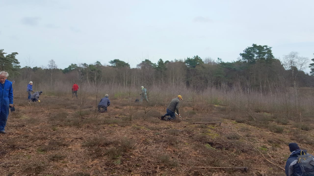
Ancient Woodland Inventory
Hannah Alred, SBIS
Gary Battell
The Ancient Woodland Inventory (AWI) was first produced in the 1980s as a paper-based exercise. Without the benefits of modern technology, and being largely desk-based, it inevitably had many errors and omissions. It also only included woods that were larger than 2ha. In the Southeast, the AWI was revised using more modern mapping technology and included the sub-2ha woodlands. This project is about expanding this work across all counties of England.
The Ancient Woodland Inventory update uses a consistent and quality-controlled methodology, set out by Natural England, to create an accurate record of ancient woodland and ancient wood-pasture in England.
This will:
- Ensure all Ancient Woodland is recorded so that it can receive planning policy protection.
- Form a key evidence base, essential to enabling Local Planning Authorities to fulfil their National Planning Policy Framework duties.
- Provide an evidence base to underpin landscape-scale plans such as Nature Recovery Networks and initiatives.
The inclusion of many smaller woods will aid protection of the larger fragments by enhancing links between them and, in some cases, buffering designated sites.
Important indicator species, such as Oxlip, often survive in the small ancient woodland fragments, therefore, designation can help protect populations of nationally scarce species. This also applies to the less popular groups like beetles or fungi where rare species are being lost before ever being recorded.
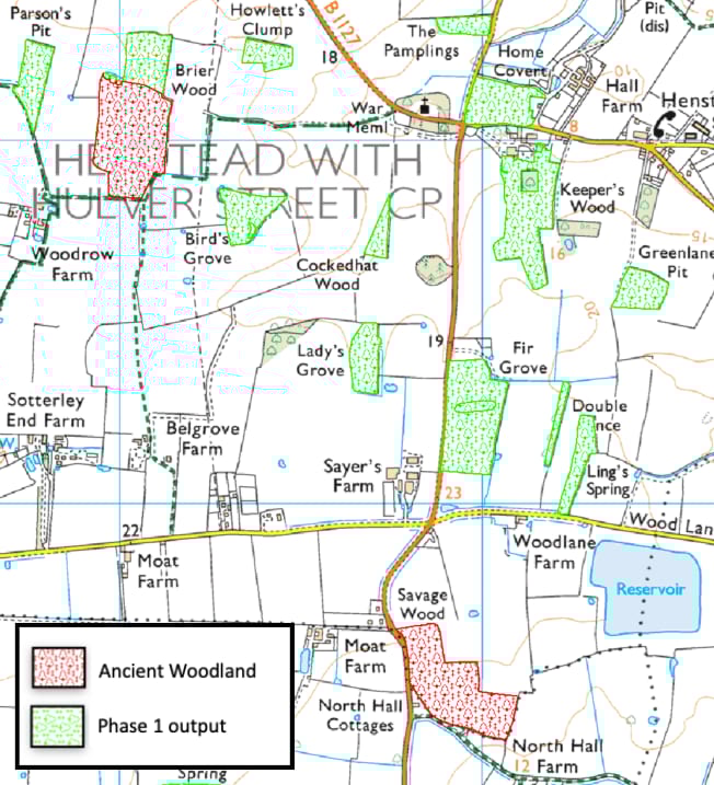
This project has five methodological phases that will utilise desk-based mapping, historical documents research and field surveys.
Currently, the project is in Phase 1. This stage involves identifying sites of long-established, and therefore potentially ancient, woodland. This examines present woodland in modern aerial photographs and 1st Edition Ordnance Survey maps from the mid1800s and takes place on a detailed grid square by grid square basis across the whole of Suffolk.
© Crown Copyright and database rights Ordnance Survey and Landmark Information Group Ltd.
© Bluesky International Ltd. / Getmapping PLC.
The following stages are:
Phase 2: cross-reference sites identified as potentially ancient in Phase 1 with sites identified as ancient in the current AWI.
Phase 3: The most in-depth phase, which will employ various historical mapped data sources to expand the chronological span of the data used and enrich the evidence base for each candidate site. This is also the phase that includes the woodland survey programme.
Phase 4: evaluate all gathered evidence and decide the status of a site – whether it should be categorised as ancient semi-natural woodland or plantations on ancient woodland sites.
Phase 5: submitting a long-established woodland dataset, a provisional updated ancient woodland dataset along with a written project report to Natural England.
For more information on ancient woodland please visit:
www.woodlandtrust.org.uk
This work is funded by The Woodland Trust and Natural England.
© Crown copyright and database rights 2022 Ordnance Survey 100023395
Suffolk Tree Wardens' community tree nurseries:
A seed-to-site success story
Helen Bynum
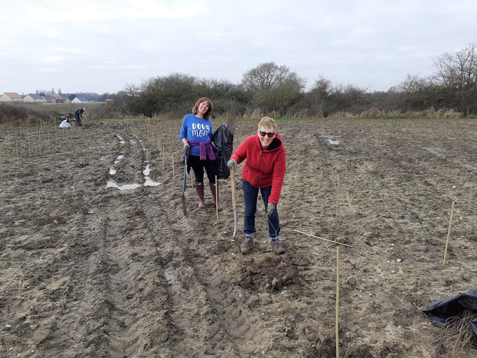
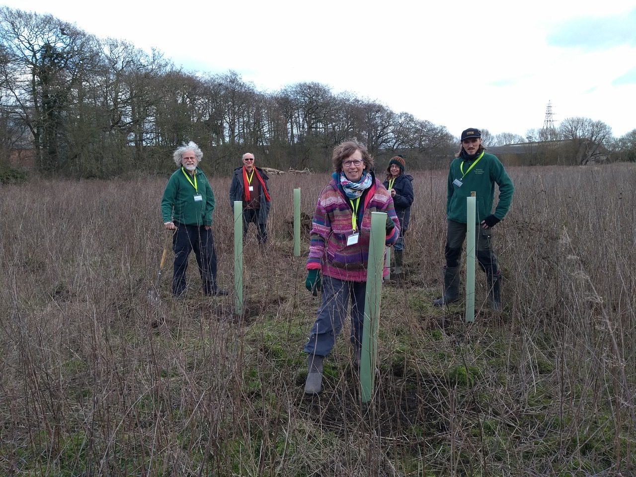
On fields that sweep down to the Deben volunteers planted 660 trees as part of the Helmingham Farm Estate agroforestry initiative
‘Field-to-fork’ has a familiar ring on the food circuit now. Local food can reduce food miles and CO2 emissions. If it is grown in tandem with nature as much as possible, local food has the potential to prevent further habitat loss and boost biodiversity. In 2020 the Suffolk Tree Warden Network (STWN) decided that local could also be better for our wooded landscapes.
The common aim among all the initial 16 Tree Nurses who signed up, is to grow local trees and reduce reliance on saplings transported into Suffolk. For several years the STWN has been delighted to partner with The Woodland Trust and SCC distributing the Trust’s commercially-grown free hedge and landowner tree packs each autumn. In the 2021/22 planting season, this meant 15,000 trees and 5,000m of hedgerow passed through our volunteers’ hands and are now settling into Suffolk’s soil. We look forward to continuing to distribute Woodland Trust plants but, as the work of the STWN becomes better known and tree planting rises up the climate crisis agenda, demand for trees is set to outstrip supply. The most recent Woodland Trust offer was taken up in record time and STWN coordinator Frances Jannaway arranged a second distribution early in 2022 to help Tree Wardens finish up their planting projects. May the spring rains be gentle and frequent though we are proud and grateful that Sicon Foundation has supported our work with a generous provision of mulch mats.
All this reads well but what’s special about the Tree Nursery project is that we are not just adding to this wonderful distribution network but, by growing our own, we are actively conserving the genetic richness of the county’s trees. Tree Nurses have carefully chosen thriving local trees as seed sources. Though climate change will affect all aspects of tree health, these healthy parents have a good chance of providing future generations of trees well-suited to their local environment. This adds an extra dimension to the ‘right tree, right place’ planting principle of The Tree Council and Woodland Trust. By being local - taking account of what’s growing where and what’s been lost over time - tree nurses can also meet the bespoke needs of new planting projects that reflect Suffolk’s unique ecologies and topography.
From seed to site
So where do the STWN tree nursery trees end up? Tree Nurses have been active in getting their year-1 trees into the ground on their own and nearby patches. Our most prominent planting so far is the local oak grown by David Appleton and planted in autumn 2021 at Redgrave Park by BBC presenter Joe Crowley during filming for the Countryfile ‘Plant Britain’ episode. Waldringfield’s scattered nursery plants will find their way into hedge gaps identified during the Suffolk Hedgerow Survey (1998-2012) tying together past and present projects in unexpected ways. However, just as we act as a hub for Woodland Trust saplings, when a message goes out on the Tree Nursery what’s app group indicating trees are needed for plantings, the nurses respond. Saplings from the 2 Fields nursery supplied the bulk of the 660-tree agroforestry planting (oak, hornbeam, sweet chestnut, field maple, walnut and crab apple) at Helmingham Estate Farms in January 2022 but others contributed too.
Going local for trees
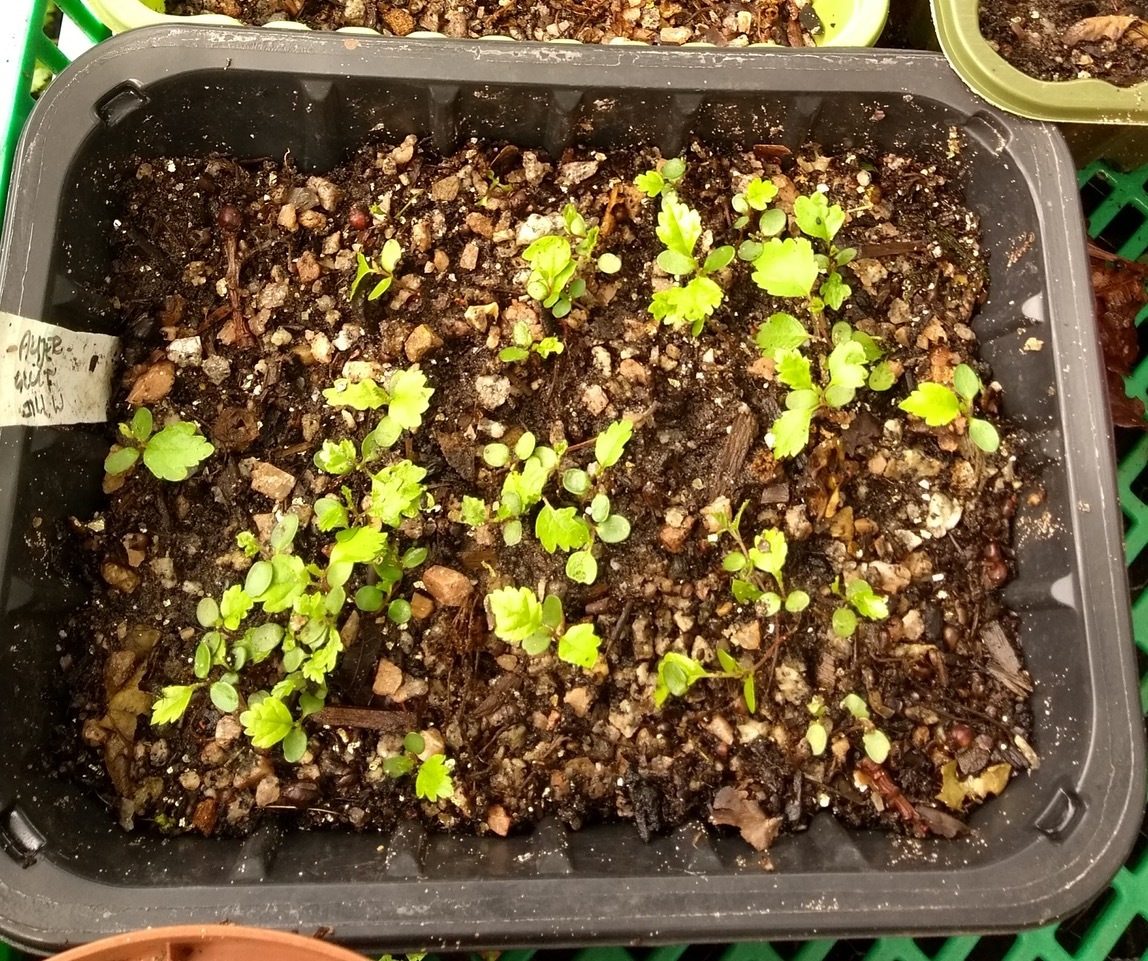
While some Tree Wardens were already growing their own trees from local seeds, a wonderful funding boost from Suffolk Country Council (SCC) stimulated the STWN’s drive to create a series of Community Tree Nurseries across Suffolk. Community engagement is vital to conservation efforts everywhere and we are proud that our nurseries helped us win the ‘Greenest Community’ category at SCC’s 2021 Greenest County Awards. The STWN tree nurseries currently range from avid growers working in their back gardens, to schools and larger-scale projects. The Red Gables Wellbeing Hub in Stowmarket and the 2 Fields Community Supported Farm in Debenham allow those with special needs or without their own space or get involved. The Eye Scout Hut nursery is due to come online this year and will be a welcome new youth project. In Waldringfield, Tree Warden Christine Fisher-Kay tapped into existing networks under the Greener Waldringfield umbrella. Together with other enthusiasts, including the local primary school, they have created a series of satellite nurseries they call the ‘scattered tree nursery’.
Alder (Alnus glutinosa) seedlings germinating in Christine Fisher Kay’s ’scattered tree nursery’, Waldringfield
From seed to site
Malt and Malted Ingredients company Muntons are celebrating their centenary this year and decided to invite their staff to help plant a celebratory 100-year wood at their Cedars Matings in Stowmarket. The saplings were planted over the winter using Woodland Trust deciduous broad-leaved stock. Part of the site also comprises the flood plain of the River Gipping which allows more specialised riparian species to flourish. Melissa Abbott, marketing coordinator at Muntons linked up with Stowmarket Tree Wardens Richard Frost, Patti Seaward and Colin Lay to establish a wildlife connectivity planting between the Gipping and an existing well-established wood on their site using Christine’s water-loving Waldringfield alders. The alders were deliberately spaced to allow other wetland species to be interplanted as they are grown on in STWN nurseries. Reintroduction of once common willows, aspen, poplars and alders is vitally important in such habitats as these trees form an essential part of a riparian vegetation zone from their binding and filtering roots all the way up to tips of their pollution catching leaves. The Muntons site is not open to the public but provides an important wellbeing space for their staff and, because of its privacy, an undisturbed area for nature to thrive. These plantings also contribute to Stowmarket Town Council’s drive to increase the town’s canopy cover.
Planting day at Muntons, Stowmarket: the start of the wildlife connectivity corridor L to R Richard Frost, Ian Kay, Patti Seaward, Christine Fisher Kay, Colin Lay
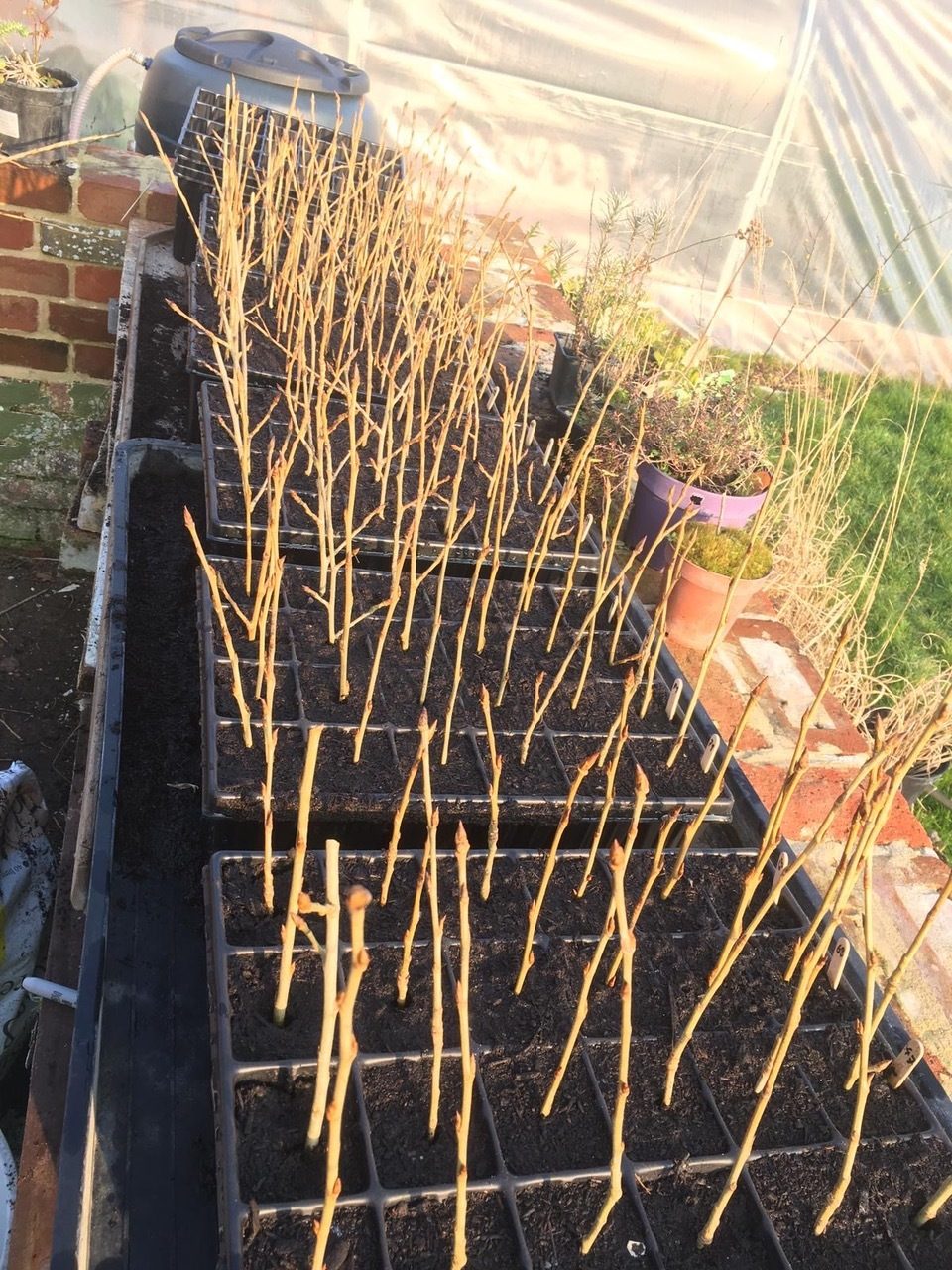
Black poplar (Populus nigra subsp betulifolia) cuttings at Langham Walled Garden STWN black poplar nursery
Trees on demand
As the tree nursery project matures the STWN hopes to nurture the important but often underrepresented species that can fill particular ecological niches. As well as the familiar Suffolk hedging trees which sustain a vast range of insects, birds and mammals on the Eastern Claylands there is tremendous scope for increasing the wet-loving and water-shading trees species for sites in the Brecks and along the feeder streams and watercourses that dissect our landscape. The black poplar was once common as a floodplain and standard timber tree in Suffolk. Captured in all its homely familiarity in John Constable’s great landscape art of the early 19th century, black poplars are now famous for their rarity. Using genetically typed male and female plants from the Dedham Vale AONB a new STWN black poplar tree nursery at Langham Hall Walled Garden took its first cuttings in March 2022 under the care of arborist and Tree Warden Steve Adams. The nursery aims to create a stock of black poplars for the county’s river and wetland restoration projects.
Forgive the cliché but tree planting is always about a vision of the future. A recent STWN grafting course was offered by Paul Read (Suffolk Traditional Orchard Group) and Celia Boyle. The aim of the course was to upskill Tree Nurses’ and Tree Wardens’ practical expertise and increase the diversity of trees growing in our nurseries. We are anticipating a demand for orchard fruit trees as part of community plantings and to help meet the needs of agroforestry. The course was a sell-out. Locally grafted trees, using heritage varieties rich in spring blossom and autumn fruit could mean more locally-grown food before too long.
If you are excited by what you have read here and want to join the STWN go to our website suffolktreewardens.org.uk or follow us on @SuffolkTrees. Our aim is have at least one tree warden in every parish.
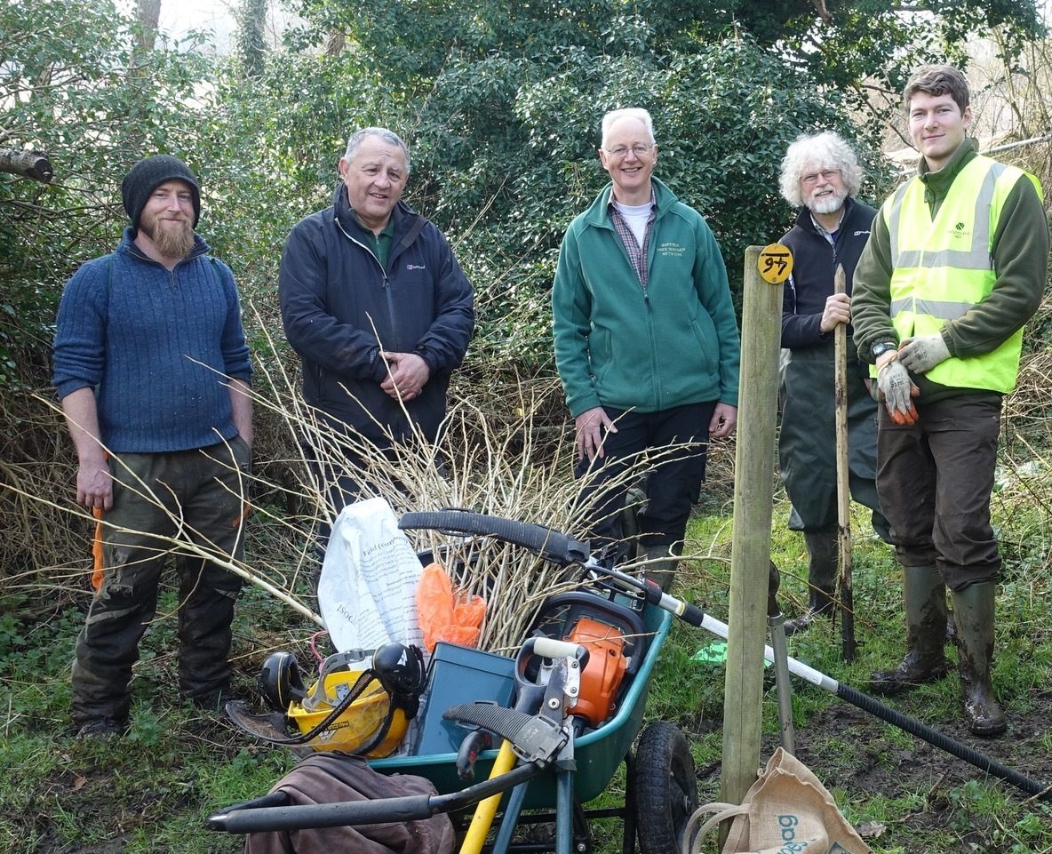
Taking cuttings of black poplar (Populus nigra subsp betulifolia) at Dedham vale AONB L to R Steve Adams, Gary Battell, David Appleton, Richard Frost, Thomas Ridgeon
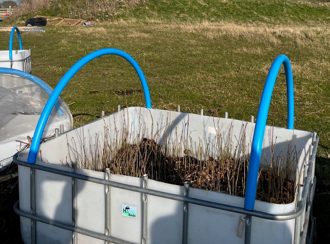
A Harry Bed™ made from recycled IBCs by young entrepreneur Harry Daly filled with oak saplings. A very effective means for mass sowings.
Roadside Nature Reserve project
Lucy Spencer, Ecologist, Suffolk County Council
Roadside Nature Reserves (RNRs) are stretches of roadside verge that support populations of rare and unusual plants and fungi, and characteristic Suffolk assemblages of flora.
Many roadside verges are very old, on the edges of routes that have changed little over the centuries. These verges are the remains of the semi-natural grassland that was once widespread throughout the country, but which has declined by 98% since 1945, due to changes in land use, intensive cultivation, and drainage.
By careful management of these sites, we aim to conserve the species on RNRs, giving future generations the chance to enjoy these remnants of ancient grassland meadows.
There are currently 117 RNRs in Suffolk (2022) with over 30 dedicated Volunteer RNR Wardens. Wardens help by keeping an eye on the verges and letting us know of any issues and by raking off the cuttings after they have been mown, to remove nutrients and keep competitive growth from other plants to a minimum.
This coming year, I will be heading out to as many of our RNR’s as I can to carry out condition surveys and to make sure the species the RNRs are protected for are present and correct! This will also allow me to see whether the species are spreading beyond the current boundaries of the RNR and whether we might need to extend it.
We are always looking for more verges to protect, so if you have one local to you that has a good floristic display over the spring and summer months, let us know! I’ll be happy to arrange a survey, see what’s there, and carry out a checklist to see if it meets the criteria for protection.
Alternatively, if you are interested in being a warden, your local RNR may need someone. Please feel free to get in contact if you would like to find out more details.
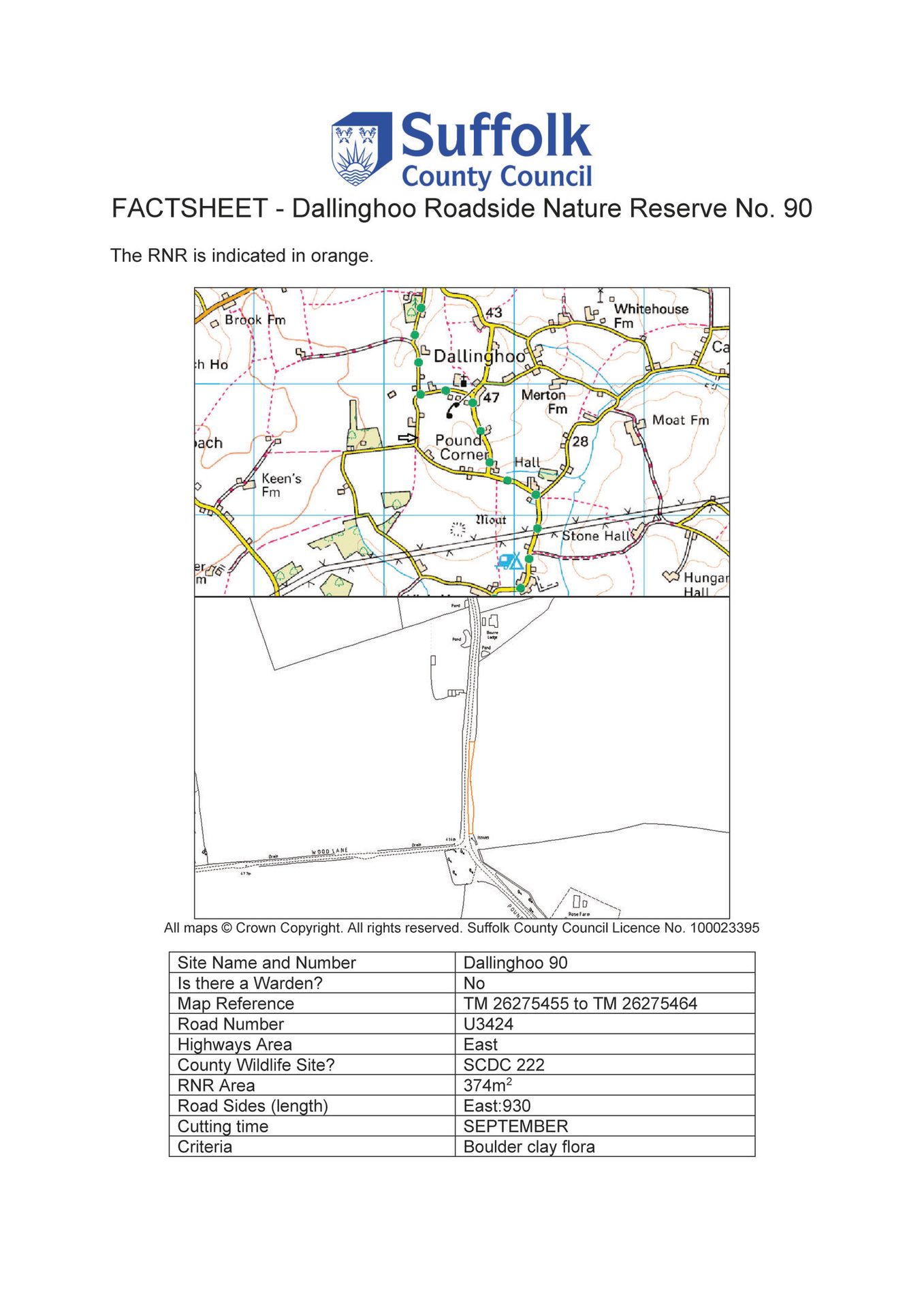
The following link shows the locations of the RNRs and also allows you to look at the fact sheet for each of the RNRs: Suffolk’s roadside nature reserves interactive map
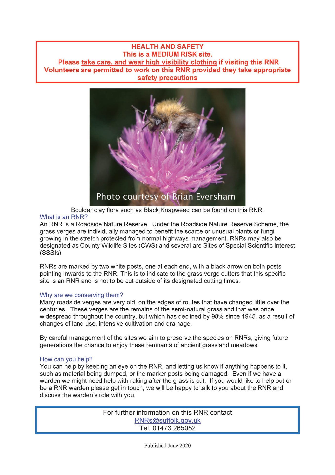
The RNR map
Green: Green icons on the map mean you can visit the RNR, but you should always take care at these sites.
Orange: Orange icons on the map mean you can only visit the RNR with safety precautions in place, some may be narrow in places and traffic management may be required to visit them safely.
Red: Red icons on the map mean the RNR is not safe to visit. Please do not visit these sites.
Blue: Blue icons on the map mean the RNR is newer and is yet to have a risk assessment. Please do not visit these sites until the risk has been assessed.
If you have any questions or would like to volunteer to work on an RNR get in touch with us at
Example fact sheet
A Local Nature Recovery Strategy for Suffolk:
An Introduction
David Smart, Norfolk and Suffolk Nature Recovery Partnership
Ben Schofield, Unsplash
Local Nature Recovery Strategies (LNRS) are a new system of spatial strategies for nature, which will cover the whole of England. They will become mandatory via the Environment Act and it is likely that Suffolk County Council will become the Responsible Authority, tasked with their set-up and subsequent implementation and ongoing management. They are designed to be tools to drive more coordinated, practical and focussed action to help nature.
LNRS will;
- agree on the priorities for nature’s recovery,
- map the most valuable existing areas for nature,
- map specific proposals for creating or improving habitat for nature and wider environmental goals.
The production of the LNRS will be evidence-based, locally-led and collaborative, to create a network of shared plans that public, private and voluntary sectors can all help to deliver.
Creating and implementing the LNRS will be a significant task requiring expertise in data, mapping, stakeholder engagement and communications. Increased capacity and resources will be required to successfully deliver the initial phase and for ongoing management. A key element will be the expertise of the Suffolk Biodiversity Information Service.
There will be challenges ensuring there are sufficient resources available, carrying out successful engagement and aligning all the key stakeholders. However, with a well-planned and implemented LNRS in place we could, for the first time, see an integrated approach to delivering targeted nature recovery, which means landscape-scale habitat creation, enhancement, connectivity and access plans.
What is it?
The Suffolk LNRS will be map-based with two distinct stages.
- Baseline mapping of current green infrastructure and protected sites with descriptions of the areas.
- Identifying suitable locations and prioritising new initiatives for nature and people (e.g. habitat creation, connectivity, species introductions, access).
The LNRS will be a tool to help co-ordinate environmental investment and deliver those opportunities and initiatives. It will also form the basis of the Government’s National Nature Recovery network.
Where?
The LNRS is country-wide and county-based, once complete there will be 50 LNRS in place across England. We will be liaising with neighbouring local authorities and taking their LNRS into account to ensure we align measures across county boundaries.
Who?
Optimising the opportunities and priorities for nature recovery will require the engagement of a broader range of stakeholders and partners than the usual ‘green’ members. The LNRS, therefore, aims to work closely with district and borough councils and relevant public, private and voluntary sector organisations to draw on and share their collective expertise.
Responsible Authority
Being county-wide, and with a wide remit, Suffolk County Council is the likely choice as the responsible authority, but this has yet to be confirmed. It will take at least 12–18 months to deliver the LNRS.
Finance
New initiatives will be funded via;
- Implementation of Biodiversity Net Gain (BNG), which will require careful alignment with the Planning system and ongoing co-ordination with our district and borough councils.
- Environmental Land Management (ELM), the ‘public money for public goods’ replacement for current landowner grant schemes.
- Nature-Based Solutions where available, appropriate and well enough established to do so. For example: using natural flood management techniques to provide habitat for wildlife as well as flood defence benefits.
- Supplementary private sector investment and/or blended finance, plans for this are still in their infancy but are very much needed if we are to realise nature’s recovery at the scale needed.
Sustainable Development Fund grants available
Tom Fairbrother, AONB
GRANTS & FUNDING
The Sustainable Development Funds in the Coast & Heaths Area of Outstanding Natural Beauty (AONB) and the Dedham Vale AONB & Stour Valley Project Area are available to a variety of local community and conservation organisations, or individuals, to support projects for the conservation and enhancement of the natural beauty in the areas.
Both funds are currently open for applications and whether you have a project that works in the arts, media, conservation, learning, heritage, food, health, accessibility, and diversity, to give you but a few examples, we welcome your applications.
Previous examples of projects funded include art workshops for people with mental illness, new fencing and gates for nature and wildlife reserves, rural training for young people, as well as visitor information at well-known landmarks in the area.
You can find out more information, including case studies of past projects, on either the Coast & Heaths AONB or Dedham Vale AONB websites.
The closing date for applications is Monday 16th May 2022.
If you have any queries, please contact AONB Grants Officer, Oka Last, on 01473 265558 or at [email protected].
© Gill Moon
Funding boost for community
nature projects in East Suffolk
Daniel Wareing, Greenprint Forum
Unsplash | micheile || visual stories
In summer 2021 the Greenprint Forum secured £20,000 from East Suffolk Council to set up a small grants scheme, Nature First, to support community level projects that enhance or promote biodiversity in East Suffolk.
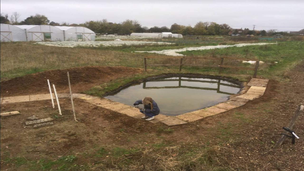
Since its launch in summer 2021, the Greenprint Forum has awarded £8,265.19 to eleven projects including the Pinetree Nature Garden in Lowestoft, swift projects in both Framlingham and Tuddenham, rewilding Jetty Lane in Woodbridge, community engagement with nature at Dip Farm in Gunton, the courtyard wildlife garden at Bungay library, Saxmundham’s hedgehog campaign, tool purchases for Saxmundham Green Team, a wildlife educational area including a new pond at Oak Tree Farm in Rushmere, and hedge laying training for volunteers in Waldringfield.
Eight of Greener Waldringfield’s hedge laying volunteers have already received their training, from professional hedge layer of over 35 years Alison Huxley. Now that the volunteers are trained, they plan to continue laying the Churchfield hedge over the next few winters and are planning to have another course led by Alison in November 2022 so that more villagers who are interested in joining in can learn.
Learning hedgelaying skills
The Oak Tree Farm are in the course of creating their wildlife educational area which will include a pond dipping area with an adjoining bog, beetle banks, wildflower meadow, wild hedgerows, a storage shed and a learning area with benches. The Oak Tree Farm will then create educational packages aimed at different age groups around these areas and create links with local schools and hope to begin offering these opportunities this summer.
Pond creation
For more information about the projects funded so far visit: Nature First projects funded so far (pdf)
The Nature First small grant scheme remains open during 2022 and is open to any community groups who are planning or running projects located within the district of East Suffolk that are intended to enhance or promote nature and who need some additional funding. Eligible projects may include work to restore existing habitats, creation of habitats, provision of nesting / roosting places for birds, pollinators and other animals, or activities to help local people of any age learn about and enjoy their local biodiversity. Eligible projects must contribute to the Greenprint Forum’s goal of an East Suffolk where the value of nature is recognised by the majority, visitors are attracted because of it and everyone actively cares for it. The scheme is intended to run throughout 2021 and 2022, and applications can be submitted at any time. Applications will be considered by a panel comprising members of the Steering Group of the Greenprint Forum.
Applications for the Landscape Recovery scheme now open
Defra
Irena Iriser, Unsplash
Land managers and farmers can apply for funding from the Landscape Recovery scheme for wildlife and river projects.
Farmers and landowners can apply for funding to support projects that will restore nature, reduce flood risks and boost biodiversity, as the first round of applications for the Landscape Recovery scheme opens.
The scheme supports more radical and ambitious land-use change and habitat restoration, such as establishing new nature reserves, restoring floodplains to help reduce the risks from flooding, or creating woodland and wetlands.
The first round of Landscape Recovery is open to individuals or groups who want to come together to deliver large (500 – 5000 ha) scale projects that focus on:
- recovering and restoring England’s threatened native species. Projects under this theme will be administered by Natural England
- restoring England’s streams and rivers: improving water quality, biodiversity and adapting to climate change. Projects under this theme will be administered by the Environment Agency
Projects could include restoring the natural courses and condition of rivers and streams, creating and improving woodlands or wetlands, or creating a mosaic of habitats for native species.
Applications close on 24 May 2022. The application process is competitive and Defra will assess applications against selection criteria focused on the projects’ potential impact, feasibility and costs and will confirm the chosen round one pilot projects in the summer. Up to 15 projects will be taken forward within the total project development budget available of £7.5m.
Information
To read more about the Landscape Recovery scheme and how to apply, visit GOV.UK
As part of submitting a bid, applicants will need to confirm that tenants and those with rights of common have been engaged prior to application and are supportive of the project moving forward into project development.
The selected projects will initially be awarded project development funding. Over the course of the project development phase, which will last up to 2 years, they will have the opportunity to negotiate public and private funding for implementation. If a project meets Defra’s requirements at the end of the development phase, they would be awarded long-term funding, allowing them to start delivering on the ground. Implementation agreements are expected to be long term (20 years plus) and we want to ensure the projects are safeguarded into the future.
BIFFA Award: Partnership
Grants Programme
Natural England/Paul Glendell
Biffa are currently accepting expressions of interest for their 2022 Partnership Grants Scheme.
Overview
Natural Environment projects should restore and/or improve the environment and the natural systems or habitats that support it. Projects should be working to Biodiversity 2020: A Strategy for England’s Wildlife and Ecosystem Services, its predecessor or a Local Biodiversity Action Plan.
You should consider the natural environment and ways to mitigate the impact your project will have both during project delivery and after funded works are complete, for example by employing local tradespeople, using sustainable materials, recycling existing components, reducing energy consumption or reducing carbon footprint.
Preference is given to projects:
- in which Biffa Award is the majority funder
- which work in partnership with other organisations
- which engage with people through improving their knowledge of the asset
General Criteria
- The applicant organisation and project must be eligible for enrolment and registration with the scheme regulator, ENTRUST. This will be a condition of any grant approved.
- Organisations must be not for profit. Local authorities cannot apply or enrol.
- Applications must be for between £250,000 – £750,000.
- Each project site must be within 15 miles of a significant Biffa operation or active Biffa landfill site.
- Each project site must also within 10 miles of any licensed landfill site.
- If you’re not the landowner you must have a signed landowner agreement in place agreeing to access for maintenance, surveying and monitoring for a period of not less than 25 years.
- There must be a minimum of 104 days of full public access to the project per year.
- Any Biffa Award grant must be used for site-based improvement work, not for movable equipment, staff core costs or storage facilities.
- The majority of costs must be direct capital delivery work.
- Biffa Award is unable to fund requests to help an existing facility meet the requirements of the Disability Discrimination Act.
- Biffa Award is unable to fund retrospectively, so you should only apply for funding for work that will take place in the future
Natural Environment projects:
- Projects must be working to Biodiversity 2020 – England Biodiversity Strategy to reduce biodiversity loss, its successor, or a Local Biodiversity Action Plan target. See 25 year environment plan.
- Research will not be funded.
- There must be a management plan in place for the key species/habitat(s) involved for each site.
Previously funded projects
200 Hectares of pollinator habitat
Buglife - Urban Buzz
Grant Received: £1,000,000
Urban Buzz is a project run by Buglife creating 200 hectares of new pollinator habitat. Over three years, Biffa Award is awarding just over £1 million to the Urban Buzz project, to support their delivery of the scheme in Birmingham, Bristol, Cardiff, Ipswich, Leeds, Leicester, Plymouth and York.
Creating new meadows
The Wildlife Trusts, Plantlife and Rare Breed Survival Trust
Grant Received: £1,000,000
The Coronation Meadows Restoration Project created 300ha of flower-rich hay meadows. A joint project between The Wildlife Trusts, Plantlife and the Rare Breed Survival Trust, a Biffa Award grant of just over £1 million allowed 60 meadows to be designated and new meadows to be created using seeds from Coronation Meadows.
Deadline:
Online Expression of Interest: 1 June 2022
Funding decision to be made November 2022
Find out more here: www.biffa-award.org/partnerships
Events
Conferences & Webinars
Suffolk Wildlife Trust
12th National Heathland Conference • 10-12 May 2022 • Ufford Park, Suffolk • www.suffolkwildlifetrust.org
Mammal Society
67th Annual Conference • 8–10 April 2022 • Online • www.mammal.org.uk
National Forum for Biological Recording (NFBR)
Curating the Past, Creating the Future: Legacies in Biological Recording • 5–6 May 2022 • Oxford University Museum of Natural History and online • nbn.org.uk
Westminster Energy, Environment & Transport Forum
Next steps for biodiversity and wildlife protection in England • 15 June 2022 • Online • www.westminsterforumprojects.co.uk
British Ecological Society
www.britishecologicalsociety.org/events
RSK Webinars
First Thursday Club – What’s what in the wet: Why and when you might need aquatic ecologists • 7 April 2022 • Online • rskgroup.com
RSK Biocensus
The First Thursday Club is a monthly scientific, specialist-led webinar created and led by RSK Biocensus, which focuses on best practices relating to the natural environment and how these could affect RSK and external businesses. Previous First Thursday Club Webinars are available on YouTube and include topics such as:
- Avoiding Boris’s “newt counting delays” to build back green
- Badgers on development sites
- Bringing the BREEAM home – Bat Boxes and Beyond – up to 79 credits under one roof
- Achieving Net Gain on-site using the Defra biodiversity metric
- RSK Wilding: Using rewilding to achieve biodiversity net gain and other natural capital benefits
- Beyond the birds and the bees – How your business relies on biodiversity
- How to be a good ecology expert witness at public inquiries
- The consideration and protection of trees on development sites
- Changes in environmental regulation
- eDNA an introduction to environmental DNA in ecology and conservation
Training
Field Studies Council
BioLinks training courses
Natural History Courses
Professional Development
Anglian Ecology
Great Crested Newts CPD
April 29th 2022 or May 6th 2022
www.anglianecology.co.uk
University of Oxford
Rewilding the UK - Potential and Obstacles • 30 April 2022 • online
www.conted.ox.ac.uk
The Species Recovery Trust
UK Habitat Classification • 28 Apr 2022
Great Crested Newts - Ecology, Conservation and Survey • 3 May 2022
Around Britain in 30 Bryophytes • 13 May 2022
Details of these and more SRT courses: www.eventbrite.co.uk
London Natural History Society
Habitat Talk: Neutral and Calcareous Grasslands • 21 Apr 2022
Habitat Talk: The Thames, Wetlands and Aquatic Habitats • 19 May 2022
Identifying Britain’s Ferns • 2 Jun 2022
Details of these and more LNHS events: www.eventbrite.co.uk