Summer 2023
Newsletter

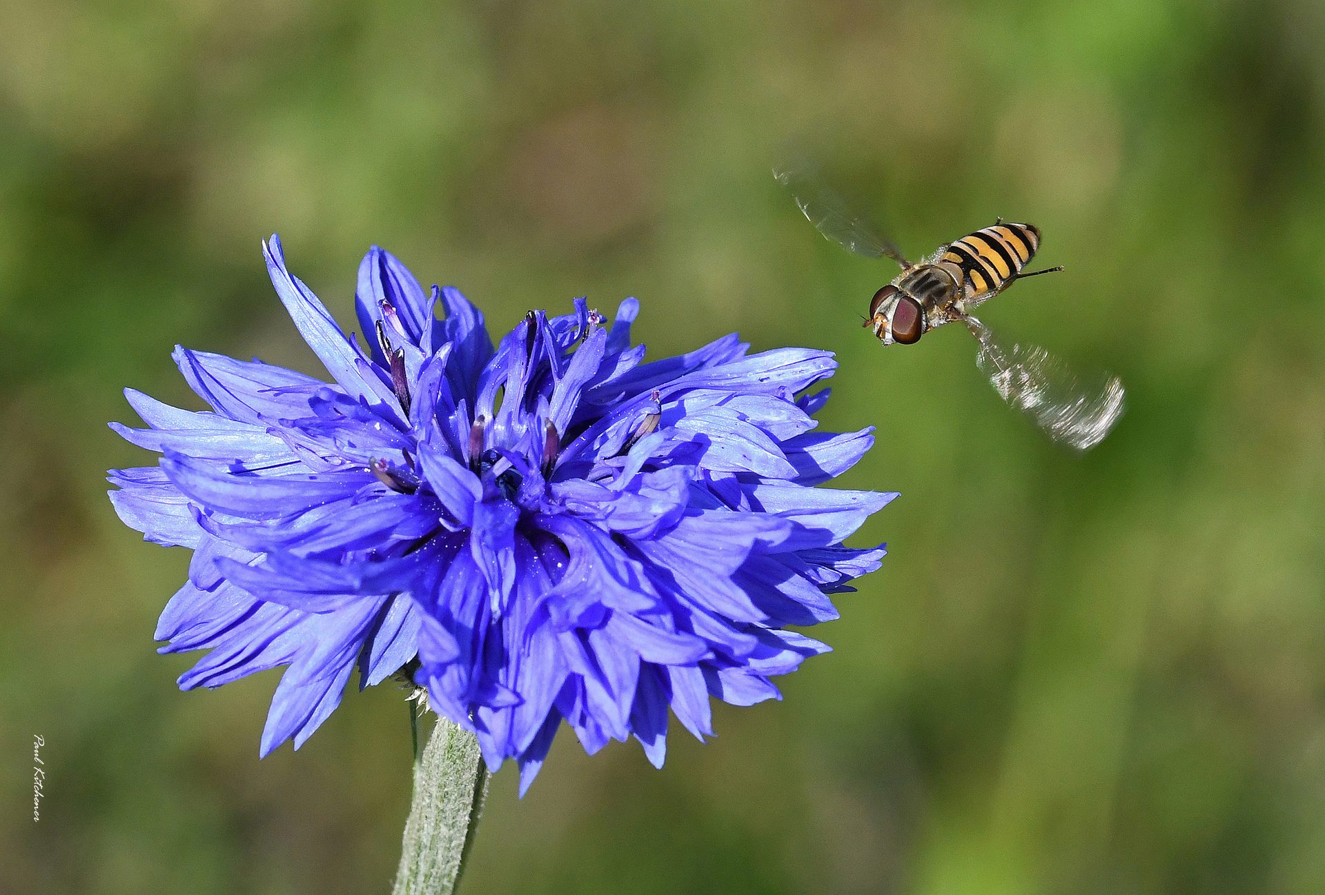
Cornflower and hoverfly with thanks to Paul Kitchener
SBIS News
Projects
Lidar-derived tree canopy polygon data
GIS polygons of tree canopies were created by Norfolk County Council’s GIS team from the Environment Agency’s Lidar data, for more information and an interactive map see tinyurl.com/tree-canopy-data.
SBIS has used these to create GIS datasets of tree canopy cover and hedgerow quality by Parish. For hedgerow quality, agricultural field boundaries were overlain and cut by the tree polygons and statistics such as gappiness, average height and volume were attached to them.
Canopy cover and Hedgerows at Parish-level
The following GIS datasets are available on our website for our registered partners to download:
Hedgerows
- Hedgerows cut by Parish boundaries (also in Excel format)
- Hedgerows cut by Parish boundaries – gaps and treed sections of the hedgerows with at least 1 tree
- Parishes with hedgerow information (also in Excel format)
Trees
- Tree canopy polygons cut by Parish boundaries
- Parishes with tree canopy information (also in Excel format)
Metadata, a brief Methodology and some Caveats are also downloadable from the site.
Before long there will be a Tree and Hedgerow area on our website where this data will be made freely available (subject to accepting the terms and conditions of an Ordnance Survey End User Licence). There will also be PDF thematic maps of Suffolk parishes illustrating some of these quality indicators by parish. In addition, there will be some examples of hedgerow quality PDF maps of individual parishes. These can be ordered from SBIS on a parish-by-parish basis, to assist parishes with their Neighbourhood Plans, in creating ecological networks and increasing biodiversity.
County Wildlife Sites, Roadside Nature Reserves, County GeoSites
Suffolk Wildlife Trust are continuing to re-write many CWS citations which are being incorporated into our database. The CWS Panel visited two potential new sites in west Suffolk, both of which met the designation criteria.
Data updates to SLA Partners
The 6-monthly GIS data updates were made available for download on the SBIS website in June. For those who download the data, notification emails including the download links were sent out. The next updates should be in December.
The regular SLA data updates were also sent to the Environment Agency and Anglian Water.
Native Black Poplar Survey recording form and map
This is live and accessible via a link on the SBIS website to registered volunteers and Suffolk Tree Wardens. Volunteers are adding new records as well as verifying existing trees. DNA testing is being carried out and the Clone numbers are being added to the data on the map. Records of new trees are sent to the Native Black Poplar Recorder, Sue Hooton, to verify.
Other data
Data was provided to the Government’s NUAR (National Underground Asset Register) to incorporate into their mapping system, so that damage to biodiversity can be avoided during the installation and maintenance of buried infrastructure.
Other activity
Statistics were calculated in GIS and provided to the Coast & Heaths AONB for their 2023 Management Plan.
Input and data was provided to the University of East Anglia (UEA) for a natural capital assessment of the County Farm estate and the Local Nature Recovery Strategy with Norfolk.
SBIS attended a Local Environmental Records Centre regional meeting.
Jane Mason Retirement
We are sad to announce that our Biological Records Officer (GIS), Jane Mason, will be retiring in mid-August. She has been an integral part in the success of SBIS and a delight to work with. We will all miss her.
I’m sure you’ll join us in wishing Jane well in her retirement. We hope she enjoys her newfound freedom and embarks on some exciting new adventures!
Recruitment for her replacement is in progress.
Number of searches and records processed from January to June 2023
Commercial Data Enquiries
A comparison of figures from the start of January to the end of June this year with the same period in 2022 shows an increase in the number of searches and species records provided in searches. From January to June 2023, we processed 296 searches and supplied 365,922 records, equivalent to 12 weekly searches with an average of 1,236 records each. These totals are an increase of 25 searches and 95,605 records from last year.
Into the Wild – Exploring the Rewilding Debate
Gen Broad
Suffolk Naturalists’ Society ‘Into the Wild’ conference in March brought together an impressive panel of experts to tackle some of the questions about rewilding and to hear firsthand accounts of Suffolk and Norfolk projects.
Held online on two half days, the audience of 120 people logged in from overseas as well as from all over the UK.
The conference conclusion was that rewilding is key to the nature recovery process, alongside ‘restoration’ and ‘nature-friendly farming’. However, we need to act speedily. In spite of 70 years of species focused conservation effort, national and international targets to halt biodiversity loss have not been met. We clearly need to do something differently and at scale.
Tony Juniper, Chairman of Natural England said: “We should be going from conservation to nature recovery in a dynamic and forward-looking process, bending back these historic curves of decline into curves of recovery.”
‘Restoration’ and ‘rewilding’ are different. Prof. James Bullock, UK Centre for Ecology & Hydrology, explained that restoration focuses on species and smaller areas, a controlled targeted approach. Marlborough Downs in Wiltshire is a classic restoration site where wildflowers sown on a degraded arable site 15 years ago have resulted in a species-rich grassland with a complex pollinator web. Prof. Bill Sutherland, University of Cambridge, believes that protecting a single species may be appropriate, as for the rare Breckland Wormwood, which has its own fenced reserve near Thetford. However, this must be part of a wider approach.
Rewilding is a cheaper, more flexible option, using natural regeneration to produce a functional ecosystem where human interventions reduce over time. Prof. Bullock described rewilding as: “…a bit like Forest Gump’s box of chocolates – we don’t know what we’re going to get”. For example, 30 years after being abandoned, Noddle Hill Local Nature Reserve near Hull has regenerated into a shrubland-grassland-wetland mosaic with a large number of song birds, great crested newts and water voles, but no woodland. Rewilding is larger scale and, since species can move through the landscape, it can provide higher resilience to climate change.
A combination of restoration and rewilding can produce a dynamic permeable landscape where sites are not ‘fixed in aspic’.
Large herbivores, such as ponies and cattle, are often used as management tools to create a mosaic of open, wooded and scrub habitats. However, Dr. Keith Kirby, University of Oxford, emphasised that we need to be clear on our priorities for a given scheme if we’re using large herbivores. Experience has shown that we have much to learn about landscape-grazing dynamics and the complicated cycle of vegetation regeneration. We can’t just leave nature to get on with it.
Dr. Kirby said: “We should be working on bigger scales and large herbivores are a great tool for manipulating the structure and composition. But I think we’ve got to recognise that some of the new landscapes that we’re going to create are not going to be those habitats and assemblages we’ve been promoting in conservation since 1949. They’re going to be different. They could be richer, I think they will be, and more interesting.”
A portfolio of approaches is needed, of which rewilding is a very important part. Prof. Bullock found that although the restoration approach is enshrined in international and national legislation and viewed more positively by policy makers, the term ‘rewilding’ has captured the public imagination, stimulating interest and debate in an unprecedented way. If we’re going to engage with the public successfully, policy makers must embrace rewilding.
Why have we been unsuccessful in preventing biodiversity loss?
Prof. Sutherland highlighted that we’re not using evidence-based science for decision making, making us far less effective at conserving nature than we might be. We should review the literature, evaluate the data, and only then decide on the best approach to take. For example, over £1 million has been spent on bat gantries over roads in the UK, but there is no evidence that they are effective. Prof. Sutherland also pointed out that standard ecological guidance is frequently wrong. Jake Fiennes, Holkham Hall Estate manager, has direct experience of this. Agri-environment schemes prescribe cutting hedgerows every three years, whereas Mr. Fiennes has found that cutting every 5/6 years works much better at Holkham Hall. Prof. Sutherland said: “What we really want to be doing is learning from practice. If we embedded experiments in conservation practice, then we could greatly improve our effectiveness.”
Mr. Fiennes pointed out that farmers need more specific evidence-based guidance on plants and invertebrates. This could reduce costs by reducing the use of fertilisers and pesticides, encouraging farmers to manage their land in a more nature-friendly way.
The conservation sector must show that nature-friendly farming doesn’t compromise either the UK’s food security or farming incomes. Alastair Driver, Rewilding Britain, pointed out that we currently waste 40% of the food we produce, whilst only about 1% of the country is under rewilding. So, wastage is a far more important issue in terms of food security. Mr. Fiennes agreed, saying: “A 21st century farmer needs to deliver a range of services alongside food production. I am of a firm belief that we can make space for nature and we can have high food and animal welfare systems. Through innovation we can ensure food security”. Land owners can diversify incomes with agri-environment schemes, camp sites, educational visits and nature tourism. Rewilding can benefit the community by promoting jobs and volunteering; improving ecosystem services and water quality; and storing more carbon.
Shifting baseline syndrome, where succeeding generations see a gradual change in the accepted norms of the natural environment, can create a false picture of biodiversity abundance. Mr. Driver illustrated this with a set of Scottish records in the 1840s in which gamekeepers caught, for example, 106 polecats, 246 pine martens, 48 otters and 63 goshawks. There must have been vastly more invertebrates and small mammals to support this number of predators than we see today!
National initiatives are moving towards larger, more joined-up sites as Sir John Lawton recommended in his Making Space for Nature Report (2010). There are 22 national landscape recovery schemes, including the north Norfolk pilot which will join protected sites from Hunstanton round the coast to Blakeney. The aim is that Biodiversity Net Gain in the planning system, which aims to leave the natural environment in a measurably better state than it was before, and the new Environmental Land Management Scheme (ELMS) will contribute to strategic, larger scale sites, particularly through the county led Nature Recovery Strategies.
Dr. Tim Gardiner’s invertebrate studies at Suffolk Wildlife Trust’s Black Bourn Valley Nature Reserve, Norton, revealed a strong return of species diversity in the fields where arable cropping stopped eight years ago. Largely left to regenerate, this 119ha site now supports a complex ecosystem with a mosaic of ponds, scrub, open grassland, woodland and floodplain grazing marsh. Species have been able to move into the site through the corridor habitats created by the nearby river valley, a railway line and a green lane. The study concluded that rewilding produces habitats (such as bare pond edges and ant hills) that are quickly colonised by common grasshopper and groundhopper species and, more surprisingly, localised species such as the Common Green grasshopper.
John Sanderson’s bold ambition is to rewild the whole of his north Suffolk farm. After 50 years of traditional farming, he sold his combine harvester in 2021 and bought a 360-degree track digger. Today, the 150ha farm comprises wood pasture, cattle grazed meadows, 30 ponds and numerous hedges. Great crested newts have returned, arable weeds are flourishing and there’s a healthy fox population. Monitoring is seen as vital to success. Dr Carl Sayer of UCL is researching the ‘ghost pond’ seed banks (sites no longer containing water, but still visible from the air) and changes in plants, birds and mammals are being recorded. Mr Sanderson said: “I’ve got no illusions. We’re not going to save any species but maybe we might continue to hear the turtle doves for a little bit longer, maybe we’ll hear a cuckoo again and who knows, we might even hear a nightingale.”
Matt Gooch describes Suffolk Wildlife Trust’s Carlton Marshes Nature Reserve as a site where rewilding means intensive management. The reserve lies within the Broads National Park, Britain’s largest protected wetland and home to a quarter of the UK’s rarest species. Under Countryside Stewardship, Peto’s Marsh and Share Marsh have been restored to wetland using diggers, dumpers and bulldozers, as well as re-installing old land drains and creating turf ponds. The site is now managed as a dynamic landscape with breeding flocks of lapwing, redshank and avocet, and 28 species of dragonfly and damselfly. Mr. Gooch said: “We have a big routine every year of messing them up again, making them muddy, and that’s shown real successes for productivity of breeding waders”.
Nature conservation is taken seriously on the 4000ha Holkham Hall Estate on the Norfolk coast. Jake Fiennes believes that intensive agriculture needs to soften to enable species to spread wider through the landscape, that connectivity is key. The farmed environment must be included in nature conservation efforts as nearly three quarters of the English landscape is in agriculture.
Alastair Driver summed up: “Traditional conservation practices on their own are not enough to achieve significant wildlife recovery in Britain. We’re know we’re going backwards on biodiversity and on mitigating the impacts of climate change. We need something additional and affordable. We need to find another way of restoring nature at scale which is sustainable. Rewilding gives us that option.”
SNS would like to thank our inspiring speakers and Bat Conservation Trust for supporting the online conference. The presentations and Q&A sessions are available on the SNS YouTube channel here.
© Edwyn Anderton, Flickr
What do birds mean to you?
Gen Broad
An exciting project to discover what birds mean to people at a personal level and to research our own Suffolk names for birds.
The results will be shared through the Ethno-Ornithology World Atlas. After reading about the World Atlas and Dr Andy Gosler’s studies on people and birds, I was inspired to launch a study in Suffolk.
As an example, my own bird story is being part of a group in the Philippines which discovered a species of bird unknown to science (the Calayan Rail). But my favourite bird is the Kingfisher. Even today, several decades later, that telltale bright blue flash instantly links me to family, sparking fond childhood memories. Examples of Suffolk bird names include Mollyhawk for Northern Gannet, Harnsey for Grey Heron and Seven-coloured Finch for Goldfinch.
Everyone is invited to take part, whether you live in Suffolk or not, so names from other counties are welcome too! The survey is extremely short and simple, comprising only four questions, focused on your favourite bird, your personal stories about birds and any Suffolk names known to you or your family/friends.
Please click on the link to fill in the form. Alternatively, I would be happy to send the form in hard copy or by email to anyone who doesn’t want to engage with online technology!
Please get in touch – [email protected]
Thank you for taking part!
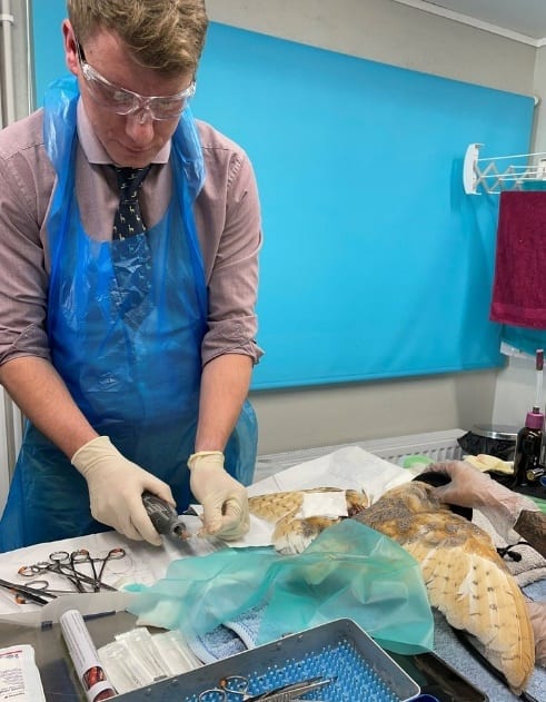
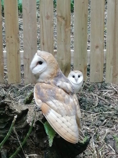
Ticky at the Suffolk Owl Sanctuary
Pin Wing and Ticky, the Barn Owls, are ready to be released
Susan Jones, Suffolk Owl Sanctuary
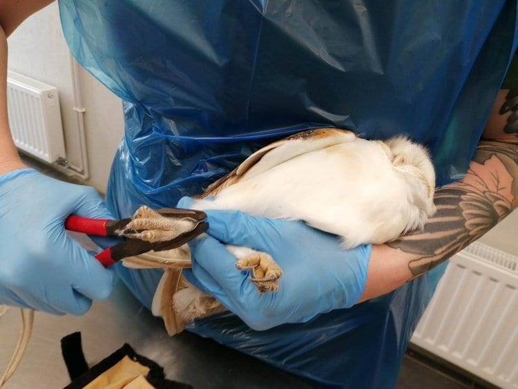
We received a call in March about a Barn Owl in trouble. She was found tangled in a hedge in a rural location but nowhere near any roads. When she arrived with us, it was apparent that the bird had a broken wing.
Thankfully, our specialist vet Dr Elliott Simpson-Brown was due to visit the next day, so he brought all his equipment to help this poor bird. Without access to an x-ray, Elliott decided to operate to determine whether the break was suitable for pinning. Thankfully, it was a clean break of the humerus, in precisely the right place to make the chance of recovery pretty good.
The operation lasted about 2 hours, being a very delicate process of attaching metal rods to the broken bones and using an external bridge to keep these stable while the bones healed. After the owl came round from the anaesthetic, we were pleased that she seemed quite perky and was happy to eat any food we put in front of her. Within a week, we were optimistic that the healing process was working, as there appeared to be no callous development around the break. Despite the metal bridge sticking out from her wing, she showed herself to be quite agile.
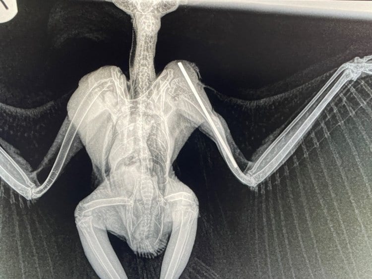
After a couple of weeks, Elliott returned to remove the bridge. The external bridge kept the bone from moving while it healed, whilst the internal pin kept the join from separating. Once the bridge was removed, an X-ray was taken to assess the positioning.
Luckily for this Barn Owl, the healing could not have gone better. The bone had knitted straight, and the callous around the fracture was so minimal it was hard to see or feel where it initially was. The pin and bridge had done their job so well that the owl could fly soon after removal.
PinWing was placed in one of our outdoor aviaries to build up her fitness after weeks of confinement while her bones healed. After a final vet check, she was ringed in preparation for her release. During this process, we confirmed that she was a female (based on the clear spots on her breast feathers) and determined that she was an older bird, showing at least 3 generations to her flight feathers. Out of interest, we measured both of her wings to see if there was any difference. Her right wing measured 292cm, while her left wing (which had been broken and had to be pinned) was 286cm. Despite this, she had been observed flying in her aviary, and there appeared to be no impact on her ability to get around.
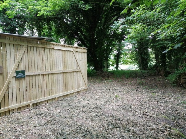
Pin Wing’s finder had offered us space to build a hack pen on his farm. This was an ideal situation as Ben, and his family were happy to monitor PinWing and her new friend Ticky, another long-term Barn Owl patient who was hit by a vehicle but had an infection caused by ticks. Interestingly, Ticky was already ringed when he arrived, and we discovered he’d been ringed as a chick last year on a farm 11km away from where he’d been found roadside.
Our maintenance team spent a couple of days installing the hack pen in the perfect location for Barn Owls, in a little patch of woods next to the farm buildings. The hack pen is designed to acclimatise long-term patients with life in the wild, with gaps left at the bottom to allow local rodents access, which in turn might lead to hunting behaviour from the resident Owls. The team provided a nest box so the pair had some shelter and perches, with a trail camera positioned to record their progress.
Pin Wing was the first out of the box, and took a moment to realise that she was in a larger space before doing a short lap of the pen and landing on top of the nest box. Ticky did the same short lap when released and landed on the ground. We retreated to observe them for a few minutes outside the pen before leaving them to settle into their new home.
Ben kept us updated on their progress, and after a few weeks, we decided that they had both gained enough fitness to be released. Ben will continue to put food out for them and monitor the trail cameras until such a time that they stop visiting the hack pen. The farm has several unoccupied nest boxes, which we hope PinWing and Ticky will utilise for any future breeding attempts.
© River Waveney Trust
River Waveney Trust News
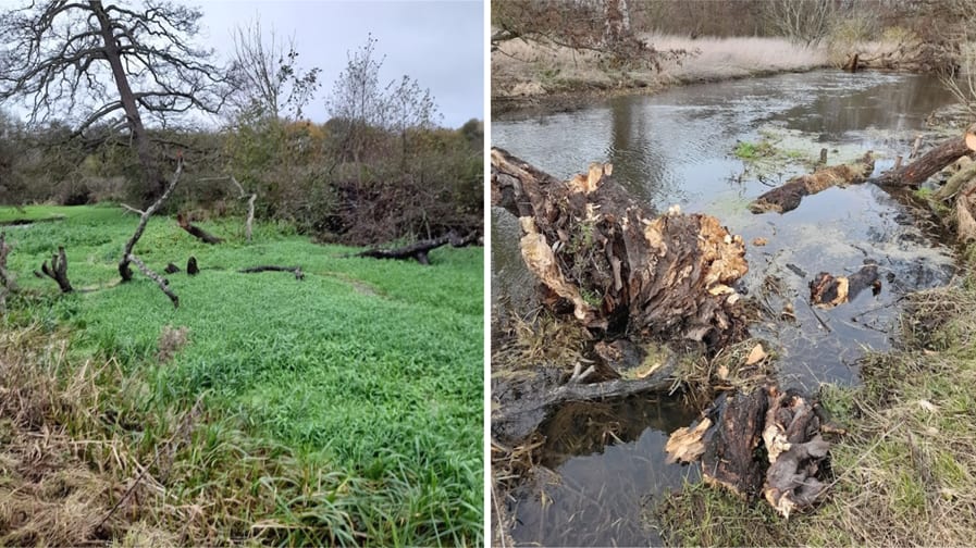
Left: November 2022, The river channel Needham is obstructed by a fallen tree and is entirely covered in floating Grass. Right: March 2023, The same tree is now secured parallel to the bank, protecting against erosion and creating in-channel diversity and habitat.
Winter and early spring is our busiest time for delivering projects – tree planting, natural flood management, in-channel work, scrapes and river restoration. Spring saw us moving forwards into new projects; read on to learn more.
River Restoration
We begin a new project targeting restoration at three sites in the catchment, Gissing, Woodton and Diss. At Gissing, we’re looking to reconnect the historical floodplain and create floodwater storage and relief areas to help protect properties at risk of flooding. This follows a Natural Flood Management pilot project completed in the village, involving bank lowering and scrape creation to encourage flood water out of the embanked stream and onto neighbouring grassland. Similar plans are proposed for Frenze Beck Nature Reserve in Diss to restore the pasture to a wetter, species-rich floodplain meadow.
River Access & Biodiversity
Our river access project continues this year and will include an application for a designated bathing water site on the river at Falcon Meadow in Bungay. Helping to ensure water quality is safe for swimmers and other river users.
Our river habitat restoration work will focus on riparian sites adjacent to footpaths, including installing woody berms, riffles, and riparian tree planting and working with landowners who are considering extending permissive access to their riverside land.
The extensive rafts of floating aquatic vegetation have been identified as a significant cause for concern by our River Wardens. In small areas, duckweed and floating grass can mop up excess nutrients in the water and provide refuge for wildlife and food for numerous invertebrates. Unfortunately, where these plants are 5 inches thick, entirely covering vast stretches of the river, livestock can drown, and recreation on the river, such as fishing, becomes impossible. Light and oxygen can’t penetrate the water inhibiting the growth of oxygenating aquatic plants and causing deoxygenation of the water beneath. In partnership with the Environment Agency and the University of Nottingham, we are conducting a feasibility study to explore how this vegetation might be harvested and used.
Our amazing volunteers continue to help control floating pennywort, and we shall continue safely retaining and managing trees fallen into the river.
Public Events Programme
We have some engaging events planned for 2023, walks, talks, films, workshops and a celebration to round off the year. Here’s what’s coming up:
- FILM: Britain’s Hidden Fishes Join filmmaker Jack Perks as he shares his new film and discusses his work exploring secretive underwater worlds. Fri 8th Sept Beccles Public Hall, 7.30pm £8 (Booking via Beccles Public Hall Box Office)
- WORKSHOP: Basket Making Workshop Learn to weave a round basket with Maxine Tricker. No previous experience is needed, and all materials are provided. Sat 16thSept Waveney Heritage Centre, Brockdish 10.30am – 4.30pm £56.50 (Booking via www.riverwaveneytrust.org - only 8 spaces)
- WALK: Waveney Walk with John Arnett, author of Waveney Walks, will lead a 3-mile walk starting in the beautiful village of Hoxne. Wed 4th Oct 11am £7 (Booking via www.pathmakers.org.uk)
- WALK: Waveney Walk with Tim Holt-Wilson Explore Needham floodplain, Instead Dale, Plateau landforms and Waveney valley landforms with a local expert and geoconservationist as your guide. Mon 9th Oct 10am £7 (Booking via www.pathmakers.org.uk)
- TALK: The Wild Life of Roger Deakin by Patrick Barkham - Patrick brings alive this great romantic in an illustrated talk and tells stories of Roger and his generation. Wed 8th Nov Fisher Theatre, Bungay 7.30pm £10 (Booking via www.fishertheatre.org)
- End of Year Celebration: Talks from River Waveney Trust 2023 Projects and Guest Speaker Dec Harleston Swan FREE Event
For further details of all events, visit www.riverwaveneytrust.org
All money raised goes to the River Waveney Trust.
© Eddi Bisulli, iNaturalist
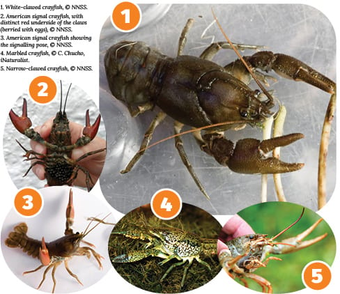
In Search of the Elusive Crayfish
Andy Went, Essex and Suffolk Rivers Trust
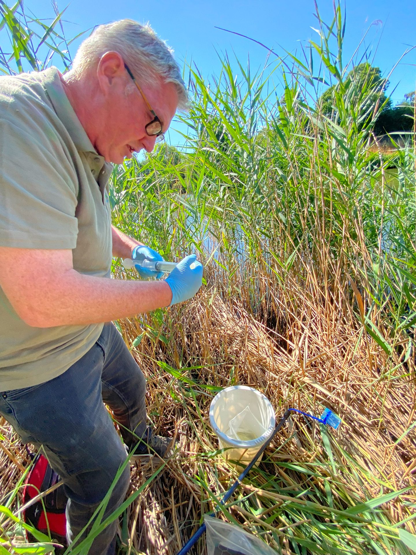
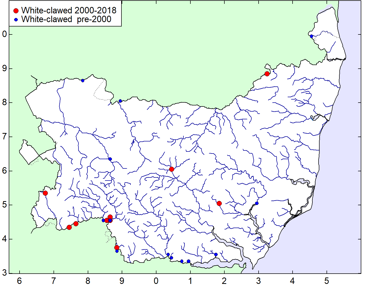
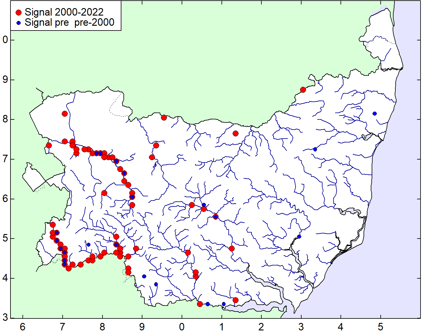
Essex and Suffolk Rivers Trust (ESRT) are embarking on an innovative monitoring programme that uses river water samples to locate populations of white-clawed crayfish (Austropotamobius pallipes) in Suffolk.
This exciting new project will use DNA analysis of the river water to identify the possible presence of white-clawed crayfish, the UK’s only native crayfish species. They are listed as ‘Endangered’ on the global IUCN Red List of Threatened Species and are afforded special protection in the UK under the Wildlife and Countryside Act 1981. White-clawed crayfish face significant threats and are increasingly rare throughout England, particularly in the South and Midlands.
There are several threats to the native crayfish species, including the degradation of suitable habitats, poor water quality and loss of flows. However, one of the largest threats comes from the introduction of invasive non-native species of crayfish into our waterways. These invasive species arrived in our river systems through accidental introductions from aquaculture, pet owners, and trade industries.
The American signal crayfish (Pacifastacus leniusculus) is the most common invasive crayfish species. These carry crayfish plague, which severely affects our indigenous populations but leave the host unharmed. These invasive species are larger and more aggressive than our native crayfish and outcompete them, displacing them and becoming dominant in the watercourses that white-clawed crayfish used to inhabit. Other invasive crayfish species found in and around East Anglia include the marbled crayfish (Procambarus virginalis) and the narrow-clawed crayfish (Pontastacus leptodactylus), also called Turkish crayfish.
ESRT uses a variety of approaches to detect, quantify, and monitor crayfish species in the UK – these range from setting baited crayfish traps to electrofishing and hand searching. The methods vary in detection success rates; each has limitations, and some can even be harmful to individuals. However, technological advances have made testing for species presence less intrusive. By simply collecting river water samples (following strict protocols), detecting species DNA using qPCR testing (which we are all familiar with now) can provide evidence of crayfish presence without disturbing or capturing them. However, even this process has limitations, as it can only tell us if they are present. It’s currently unable to quantify population size, but it’s a convenient tool if you only want to know if crayfish are present.
Last year the Essex Crayfish Project, completed by Essex and Suffolk River Trust (ESRT), and funded by the Essex and Suffolk Water’s Branch Out funding scheme, advised that white-clawed crayfish were most likely extinct in Essex after they found no traces of their DNA in the water sampled. However, American signal crayfish DNA was found in all the sampled watercourses, suggesting they have displaced our native species across Essex.
This year ESRT is embarking on a similar project in Suffolk, kindly funded by Essex and Suffolk Water through their Branch Out funding. Over the summer, we will test water samples from Suffolk’s rivers for signs of white-clawed crayfish. Historic species data held by the Environment Agency will guide our search, focusing on river systems across Suffolk that have post-2003 records of white-clawed crayfish. However, we will also sample watercourses with suitable habitats, water quality, and flow to determine if there are relic populations of these rare crayfish species.
ESRT will use the data from this project to understand how to help protect our native crayfish species and mitigate against their extinction in Suffolk.
© Amanda Slater, Flickr
Ancient Woodland Inventory
Hannah Alred, SBIS
SBIS has been working on updating the Ancient Woodland Inventory (AWI) for Suffolk since November 2021. The project has been progressing steadily with promising results.
Natural England commissioned the update of the AWI nationally to be investigated at a county level, providing support and guidance as the project is completed. When work was initially undertaken to map Ancient Woodland in Suffolk, major ancient woodlands were captured, providing a good start for the inventory. This project is looking to further that work by investigating Suffolk’s historical records and going into finer detail than was previously possible. Woods of an area as small as 0.25ha can now be included. With the aid of digital mapping and the availability of resources online, the data gathered for this project will provide a clearer and more substantiated inventory of ancient woodland in Suffolk.
Thus far, work has been undertaken to investigate the presence of woodland on Ordnance Survey Epoch 1 maps (1861-85) and aerial photography (2018-20). Subsequent comparison to the current Ancient Woodland Inventory (AWI) has revealed areas of potential new ancient woodland and some possible AWI errors that need to be checked. This update sees the addition of Wood Pasture and Parkland habitat that shall be added where substantial historical evidence is available.
Currently, work is being undertaken to examine historical maps and documentary evidence to build a history of each woodland site. This includes accessing archives held at The Hold in Ipswich as well as using online resources. Each site will need evidence of woodland presence from 1600 to the present using 50-year intervals to be taken forward as a possible addition to the AWI.
Work is also underway to conduct Ancient Woodland surveys by a wonderful group of local volunteers investigating woodland all over the county. These ground truthing surveys have been instrumental in identifying ancient woodland species presence, woodland structure and management and providing expert opinion on the ancient status of each woodland. Thank you to all our volunteers for their time and hard work.
Once historical evidence and survey data has been amalgamated for potential new ancient woodland sites, each case shall be reviewed to decide if that woodland shall be put forward as a possible addition to the AWI. This is exciting work, and we at SBIS are keen to see how much ancient woodland will be added and where exactly this is. Once Natural England approves the additions, a review of the inventory update be published and available to the public; we shall be sure to provide an update on this closer to the time.
For more information on the project, please get in touch with [email protected]
© Richard Parmee
Mini Meadows: Changing Management and Mindsets
Richard Parmee, Babergh and Mid Suffolk Councils
Babergh and Mid Suffolk Councils are expanding the amenity grass that is taken out of regular mowing and managed as meadows instead to help address the loss of native wildflower meadows and the species they support.
Changing grass management has generated considerable debate amongst the districts’ residents and revealed problems internally in rolling out the new management approach. We still have much to learn to help further expand this approach, addressing public concerns and ensuring we get it right internally.
Background
In 2020 both councils declared a Biodiversity Emergency. In response to this, we produced and adopted a Biodiversity Action Plan, which included the following:
Meadow planting: Where feasible, and in consultation with local communities, we will replace manicured grass and mown verges with meadow planting to encourage biodiversity.
Purchase a cut-and-collect mower, identify trial sites for initial areas, and then develop a long-term meadow planting programme.
What have we done?
We purchased the mower, created one new meadow area (with great success) in one parish, and removed several areas from regular mowing between 2020 and 2022. In one area, opposition to anything other than mowing caused problems. We consulted about creating another meadow on one site but encountered heavy opposition, so we did not proceed. In addition, the lack of staff capacity meant the programme wasn’t progressing as rapidly as intended.
I joined Babergh and Mid Suffolk Councils in May 2022 in a new post created to address this lack of capacity. Soon after starting, a local councillor requested that we stop mowing an area on a residential estate in Stowmarket after reports of rare orchids came in. During my visit, I found a few Pyramidal Orchids just starting to appear, and I requested that the areas they grew on be left unmown for a while.
Returning a few weeks later, the number of Pyramidal Orchids had increased considerably, and I also found a few Bee Orchids. By chance, the dry spring had slowed grass growth, so the mowing team didn’t need to visit as often as usual. As they hadn’t mown areas nearby for a while, I soon found orchids everywhere I went across the estate.
At about the same time, I met with the local environmental group, who had requested that we leave some verges unmown to ‘rewild’. We looked at potential sites that also hadn’t been mown for a while, and we found a range of native wildflowers on some sites, including a few orchids.
We then decided to stop mowing more verges on the original estate and some of those elsewhere. The mowing team were about to start their round in the town, so given there was no time to consult local residents. We decided to stop mowing and see what feedback we got. At first, there were a few complaints about us not cutting the grass, assuming we had forgotten to do so. We explained why we had left some areas to grow, to which we had a mixed reaction. To help make clear this was a deliberate policy, we kept pavement edges and some desire line paths mown regularly.
As the areas continued to grow, the number of complaints increased a little, but we also started to have messages of support, relishing the display of orchids. By now, there were hundreds of Pyramidal Orchids on the first estate, plus tens of Bee Orchids. One area also had at least fifteen other native wildflowers visible and looked fantastic.
We continued to leave all areas, sometimes adding a few more where there was a good display of wildflowers, until late July. The scorching, dry weather raised concern over wildfires and hastened seed setting, so we started to cut and clear the areas of arisings.
The complaints gradually decreased as people started to appreciate the results, got used to the change, or gave up. We had a face-to-face site meeting in an area with continuing complaints, where we reached a satisfactory compromise.
We were also aware that the debate took place on social media, with some complaining about the appearance and others stressing how important it was we did this and how they liked the new look. This peer pressure sometimes caused objectors to back down.
Our approach in 2022 was, to an extent, made up as we went along to avoid missing the boat for that year. We made some mistakes, most notably when one of the regular team took annual leave, and his replacement mowed some of the orchid-filled areas, unaware that they should be left.
Overall, we received nearly as many messages of support as we did complaints. Given that people are more likely to complain about something they don’t like than praise us for something they do, we saw this as a positive outcome. We had several messages asking us to do the same in other towns and villages, having seen what happened.
What are we doing now?
Our experiences in 2022 have helped us plan for 2023. We aim to expand the approach across a much wider area. We have selected sites where there is a request from the parish or a community body, so we know there is some desire for the change. We visited sites to assess their suitability, looking at site use by the public, highway visibility and local conditions. The Biodiversity Action Plan set out that new areas would be prepared and seeded, with time ahead of this work to allow for public consultation.
Despite over 20 years of regular mowing, most areas contained a wide range of native wildflowers. These are likely to be remnants of the pre-development habitat. If we had prepared and seeded these sites, we could have harmed important species and ended up with a more generic range of wildflowers.
So, for 2023, we are presenting the expansion as a trial with two objectives:
- To see what native species were already present, thus informing us of whether there was a need to prepare and seed the area, and if so, what would be the best species; and
- To see how people responded to the change so that we didn’t invest time and money on cultivation, only to find people wanted short grass.
We have built consultation into the trial rather than taking place ahead of any change. Doing it this way, we get feedback on how areas actually look rather than how people perceive they may look.
On the trial sites, we put signs containing the phrase: “We’re letting it grow to help flowers show”. It took some time to agree on this as we wanted to avoid the commonly used phrase “Pardon the weeds, we’re feeding the bees”, as many of the objections were that “There are no wildflowers, only weeds and long grass!”, and we didn’t want to reinforce this.
The signs also include a QR code that takes people to a webpage, where we set out what we are doing and why and ask for public feedback. We know not everyone will use this route to contact us, instead going through other routes such as our Report It site or via Customer Services. However, all messages relevant to the trial sites make their way to us, included as part of the consultation.
The public response has been variable, with some areas attracting considerable objection. The wet spring has caused problems, as the grass has grown much taller than last year, making flowers less visible and some areas look less acceptable.
The range of objections has been considerable, including untidiness, stopping children from playing, blocking access, the risk of ticks and grass seed to dogs, inability to clear up dog mess, weed seeds spreading into people’s gardens, attracting rubbish, attracting rats, causing hay fever, it being merely a cost-saving exercise under the fake cloak of biodiversity, and in one case a breach of our legal obligations under the Open Spaces Act 1906.
We respond to all the complaints, stating why we are doing this, making clear it is a trial and not a permanent change, and asking for patience to allow the trial to run its course. In many cases, people accept the explanation, and we hear no more from them. Some don’t accept this and continue to object, in a few cases leading to official complaints.
We also get messages of support that help balance matters. It is clearly a divisive issue for some, also played out on social media platforms. However, overall the level of complaints has still been lower than we feared, and some people have come around to the idea, despite initial concerns.
Some complaints have resulted from internal errors, where we have mown areas that should have been left or vice versa. The mowing team have had to take on this new approach, and some are more willing than others, leading to variable implementation.
We have drafted a Grassland Management Strategy to support this initiative, which is currently out for consultation. It will provide various options for grass areas, including amenity and meadow management. Adopting this will give greater backing to the work already carried out.
What have we learned?
There have been mistakes and areas where we can do things better. These fall into two categories:
Making things better for the public
- Ensure we cut all pavement edges and desire line paths from the outset, then maintain them appropriately throughout the season. This approach helps make clear there is still management taking place, makes the appearance more acceptable to many, and helps prevent complaints about obstruction, clearing dog mess and worries about grass seed.
- For large areas, keep some areas mown short. Doing so means there is still ample short grass for those that prefer it.
- Keep a good balance of long grass and mown areas – don’t leave them all long. Again, this means there is plenty of space for children to play, socialising and dog walking.
- If we have a wet spring, look at getting one or two initial mows in before an area is left to help keep down the grass. As long as we don’t mow after early May, most wildflowers, including the orchids, will be unaffected.
- We may need to remove some species selectively. Dock and thistles may generate increased hostility, so removing those before they have a chance to spread helps keep support.
- If it is clear little grows but long grass, we will consider adding a suitable seed mixture to create something more visually appealing. Long grass alone is better for wildlife than mown grass but harder to sell to the public than a swathe of colour.
Doing things better internally
- We need a failsafe system to ensure the mowing team knows where to leave and how to manage areas. We have mapped many on our GIS, but limited staff capacity means this still needs to be completed. Some of the mowing team prefer to avoid using digital mapping. Therefore, we printed maps and put them in the staff vans to counter this.
- We must explain the management plan to the mowing team. The team are public-facing and sometimes bears the brunt of public frustration. If staff understand the plan, they can explain it to members of the public. Staff also need to know who to pass complaints on to be able to avoid confrontations with residents.
- Getting the staff on board also helps identify where to expand in the future. The staff know their patch well, sometimes spot unusual flowers, know how the public use areas of grass, and local people may ask them to leave some areas for the bees that still need to be left.
© Sarah Kilshaw, Ipswich Tree Warden Network
Celebrating a successful first year for the Ipswich Tree Warden Network
Ipswich Borough Council
Since launching at the Suffolk Show in 2022, the network has grown to 15 dedicated local volunteers, all passionate about protecting and planting trees in the Borough.
In its first year, the network has planted 3,000 trees in parks and open spaces across Ipswich, including new hedging in Chantry Park and a new community orchard near Bramford Lane. Tree planting events were also organised in Gippeswyk Park and Murray Road Recreation Ground in honour of Her Majesty Queen Elizabeth II through a collaboration with Trees for Cities.
The network not only focuses on planting trees but also helps to look after and maintain trees planted in recent years.
In the coming months, the group will attend events to raise awareness of the importance of trees and prepare a seed collection to grow new trees for future planting.
Councillor Phil Smart, Portfolio Holder for Environment and Climate Change at Ipswich Borough Council, says:
“Thank you to our amazing Tree Warden volunteers for giving up their time during the network’s first year in operation. Thanks also go to the Tree Council and the Suffolk Tree Warden Network for their support in establishing the network.
Our volunteers do so much more than just plant trees, as they help to care for and maintain them for years to come, plus identify new possible locations for tree planting.
The Ipswich Tree Warden Network played an essential part in helping Ipswich to retain its Tree Cities of the World (TCotW) status, and we hope by recruiting more volunteers, we can grow the network and further its success.”
To find out more about joining the Ipswich Tree Warden Network, click here or email: [email protected]
© Emma Aldous, SBIS
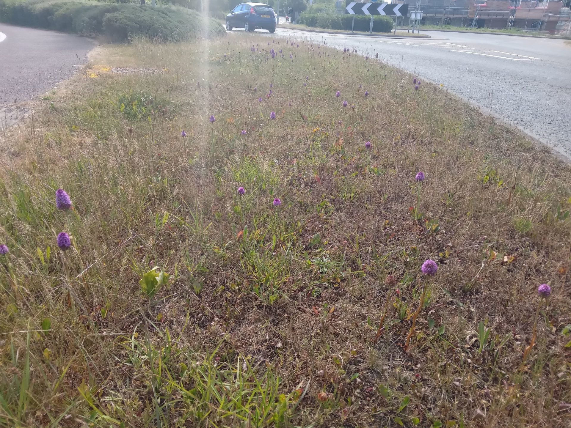
Orchids Galore!
Emma Aldous, SBIS
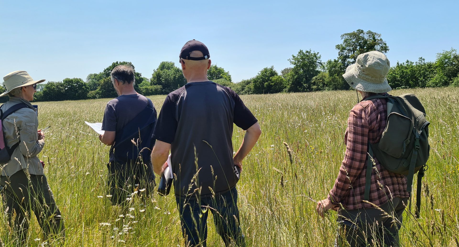
On a beautiful day in June, County Wildlife Site (CWS) panel members visited two sites where landowners wanted to extend their CWS boundaries.
We look forward to site visits and keep our fingers crossed for good weather. This time we were blessed with a gloriously sunny day. The first visit was to a farm in Elmsett with one meadow that is already a CWS. The landowner proposed an extension to include three more fields connecting the site to a nearby SSSI. The meadows in question were semi-improved and cut for hay once a year. One regularly had the cuttings left, and the others had the hay baled and removed. All the meadows had a significant diversity of flora, and from looking at the different species, we could see that the soil composition became more chalky as we moved further from the existing site.
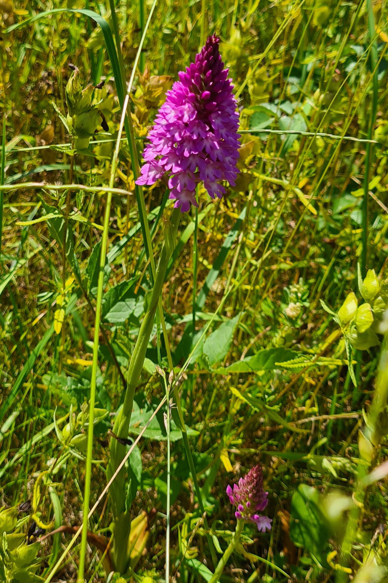
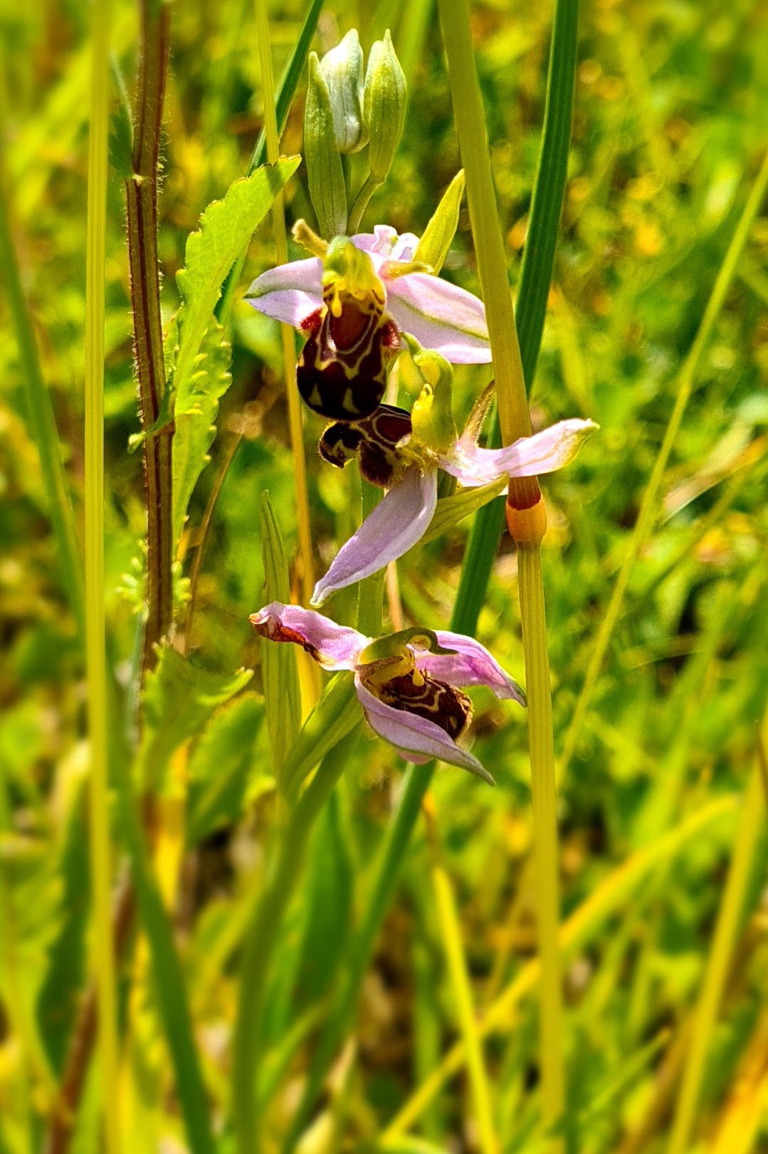
We were delighted to see many orchids in flower, including the Pyramidal, Man, Common-spotted, and Bee orchids. After a quick count, we discovered that the considerable number of Man orchids present made it the second-largest colony in Suffolk!
Other plants spotted included Meadow barley, Rattle, Fairy flax, St John's Wort, Scabious, Bladder campion, Quaking grass, Bedstraw, Musk mallow, and Sweet Vernal Grass – with a lovely fragrance and a vanilla-like flavour it was historically a favourite chewing grass.
Despite being mainly focused on the plant life, we also spotted the following:
- Blackbird, Blackcap, Blue tit, Buzzard, Chiffchaff, Collared dove, Dunnock, Great spotted woodpecker, Greenfinch, Robin, Stock dove, Whitethroat, Woodpigeon and Wren
- Brown hare
- Meadow brown, Small heath dragonflies and grasshoppers
Before our second site visit, we stopped for a picnic lunch and then hunted for a Lizard orchid to confirm the record held on the SBIS database.
Then we went on to the second CWS site, Hawstead village green. The parish council leaves the meadow to grow and cuts for hay in July. The existing CWS boundary stops at the edge of a road that crosses the green, and the parish council wanted to include the area on the other side.
The proposed extension had a variety of habitats, a small meadow managed as part of the larger CWS and an adjoining woodland with open glades and a stream, where we spotted a school of small fish darting under tree roots. The parish council have created a footpath and picnic area through the woodland for residents to enjoy the site. After our inspection, we had a guided tour of the other parish council-owned land containing some of the last remaining Elm trees in Suffolk.
Both sites now go forward to the next full CWS panel meeting for discussion.
Plant Atlas 2020
Mapping Changes in the Distribution of the British and Irish Flora
The new Plant Atlas 2020 is the most in-depth British and Irish flora survey ever undertaken.
This third edition builds on the two previous plant atlases published by the Botanical Society of Britain and Ireland (BSBI), produced in collaboration with the UK Centre for Ecology & Hydrology (UKCEH) and the Joint Nature Conservation Committee (JNCC).
Thousands of botanists spent 20 years recording wild and naturalised plants across Britain and Ireland, collecting over 30 million records. SBIS played a part by contributing several hundred thousand records and writing some of the species accounts.
The two volumes combined run to over 1,500 pages and weigh in at a whopping 8.2kg! However, if your bookcase isn’t up to that, don’t worry – all the information is freely available online, with valuable new information on trends and phenology and detailed (tetrad level) national distribution maps for thousands of species.
Of the 3,445 plant species recorded, 1,692 are native to Britain and 1,753 non-native. Most non-native species, many of which have been deliberately or accidentally introduced into the wild by humans, are benign. However, some, such as New Zealand Pigmyweed and Sitka Spruce, have become invasive, outcompeting native plants in some locations.
BSBI and UKCEH scientists spent two years analysing trends based on these records. Their report shows how species’ distributions have changed since the 1950s, with the ranges of 53% of all native plants and 62% of ancient introductions estimated as having declined. The chief driver is the loss and conversion of semi-natural habitats caused by changes in land use. In addition, climate change has resulted in the decline of some native plants but provided species originating from warmer countries with more favourable conditions to survive and thrive.
Britain’s Changing Flora summarises the key findings from the Plant Atlas 2020 project, assessing changes since the 1950s and analysing the drivers of change, such as habitat loss, pollution and climate change.
Key conclusions include:
- Damp meadows have been drained, leading to substantial declines in plants such as Devil’s-bit Scabious
- Agricultural intensification has led to an estimated 62% decline in ancient arable wildflowers, such as Corn Marigold.
- Many native mountain plants such as Alpine Lady-fern, Alpine Speedwell and Snow Pearlwort, which depend on areas where the snow lies late in the spring and summer, have declined in distribution due to climate change. Still, some southern species, such as Bee Orchid, have benefited and spread further north.
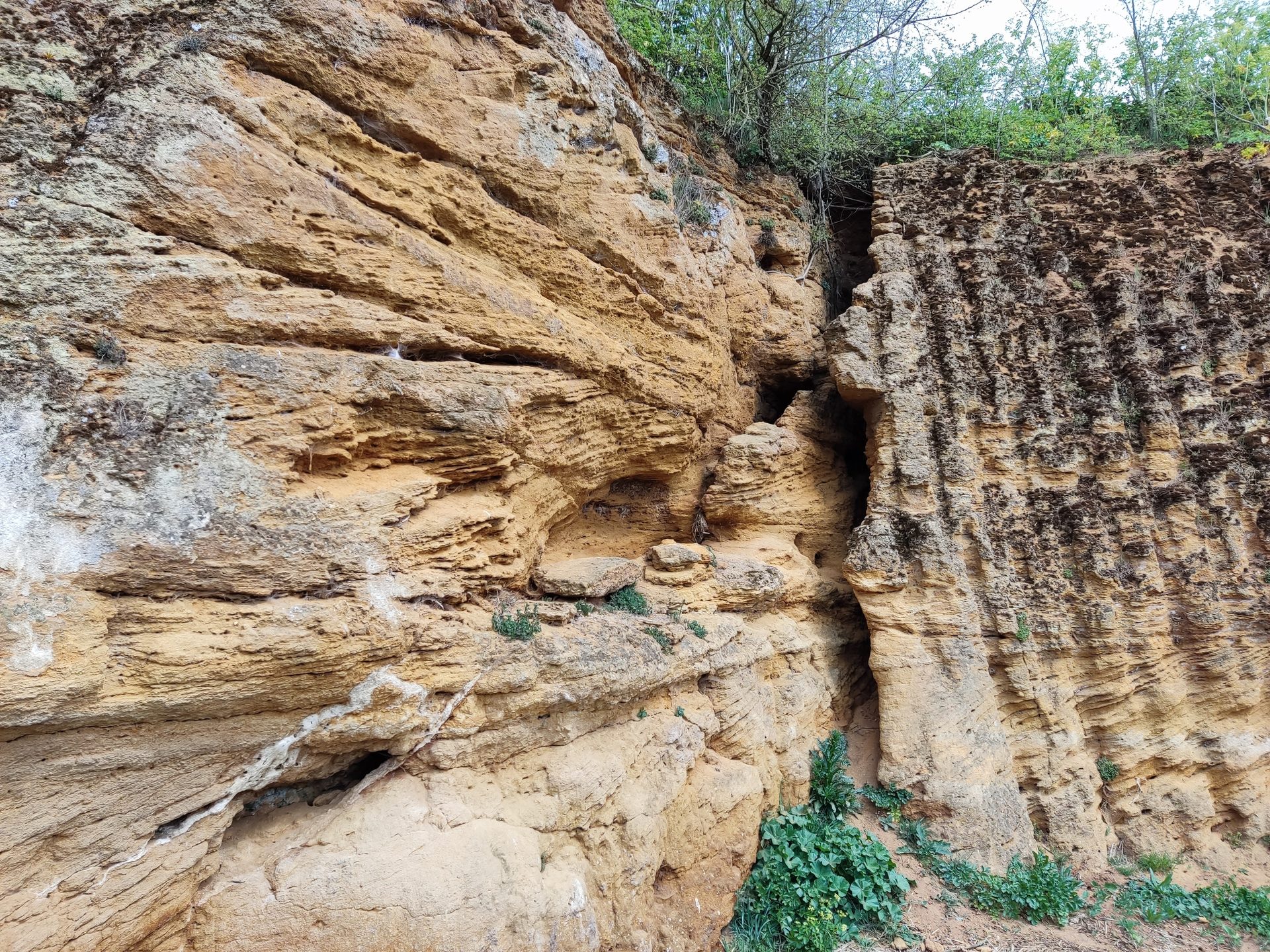
Cairn built on Thorpeness beach by Henry Fletcher using Coralline crag.
Suffolk’s Coralline
Crag Rock-Bed
Caroline Markham, Geosuffolk
GeoSuffolk’s latest leaflet, published in June 2023 celebrates a deposit unique to Suffolk and found in the Orford/Aldeburgh area of the county.
Rather than the abundant fossil molluscs, for which it is well known (see SBIS Newsletter Autumn 2022), we wanted to focus on the Rock-Bed, an indurated layer of the Coralline Crag which has been used as a building stone in our county for hundreds of years.
Many of the Coralline Crag exposures are SSSIs, and almost all are on privately owned land, making it a challenging subject for a public leaflet. Buildings with Rock-Bed in their construction provide an opportunity for public access – we used Chillesford Church (tower), Wantisden Church, Greyfriars wall at Dunwich and the interior of Orford Castle in the centrefold of the leaflet. The Coralline Crag pit in the grounds of Orford Castle is the only one with public access to the deposit in situ. For this reason, GeoSuffolk has designated it a County Geodiversity Site. If you want to hold a piece, Thorpeness Beach is the place to go, where Coralline Crag blocks eroded from an offshore outcrop are scattered across the shingle. Thus one side of the A4 three-fold leaflet shows sites the public can visit.
With the landowners’ permission, we have used photos of some of the SSSIs on the other half of the publication. (We have several recent ones thanks to our surveys for Natural England over the last couple of years – see Newsletter Spring 2022). Two of these, Richmond Farm Pit, Gedgrave and Rockhall Wood Pit, Sutton, can both be viewed from a public right of way and illustrate the aesthetic impact of this creamy-coloured limestone. We used Crag Farm Pit, Sudbourne, to depict how the Coralline Crag was quarried and the geological structures and lithologies which facilitated this. Finally, there is a photograph of the fantastic ‘troglodyte’ caves dug into the Rock-Bed in Valley Farm Pit, Sudbourne – a different way of using it for shelter.
We would like to thank all of the Coralline Crag landowners for their help and interest and Coast and Heaths AONB for supporting this leaflet through their Community and Conservation Fund. Suffolk’s Coralline Crag Rock-Bed can be found at various outlets around Aldeburgh and Orford or downloaded from the GeoSuffolk website.
P.H.O.E.B.E. Centre walk
Landscapes for All
in Suffolk and Essex
Tom Fairbrother, AONB
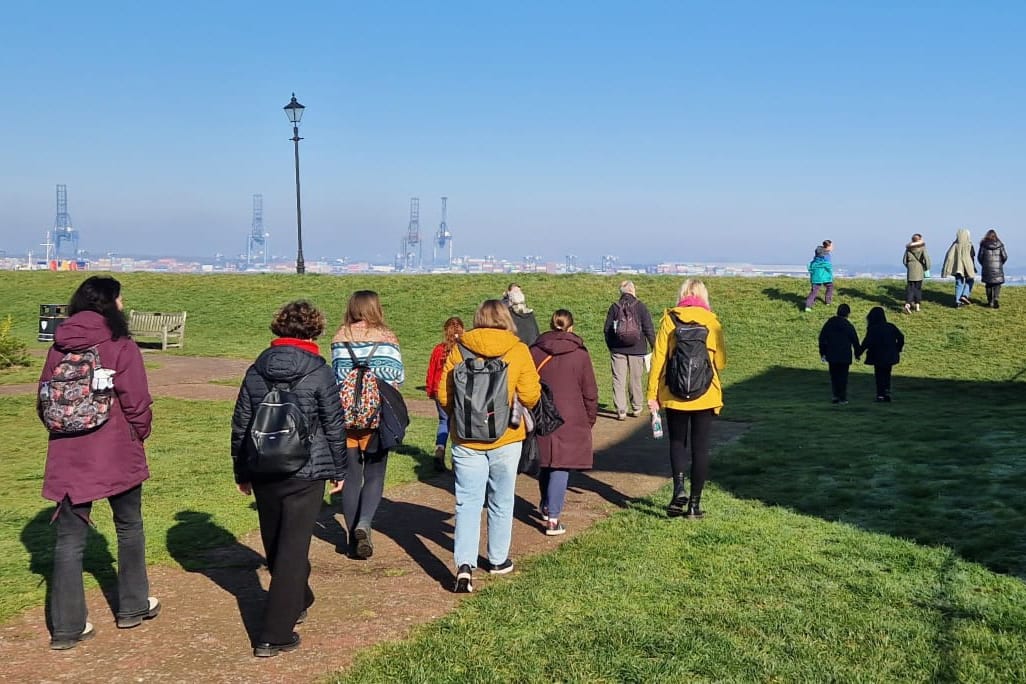
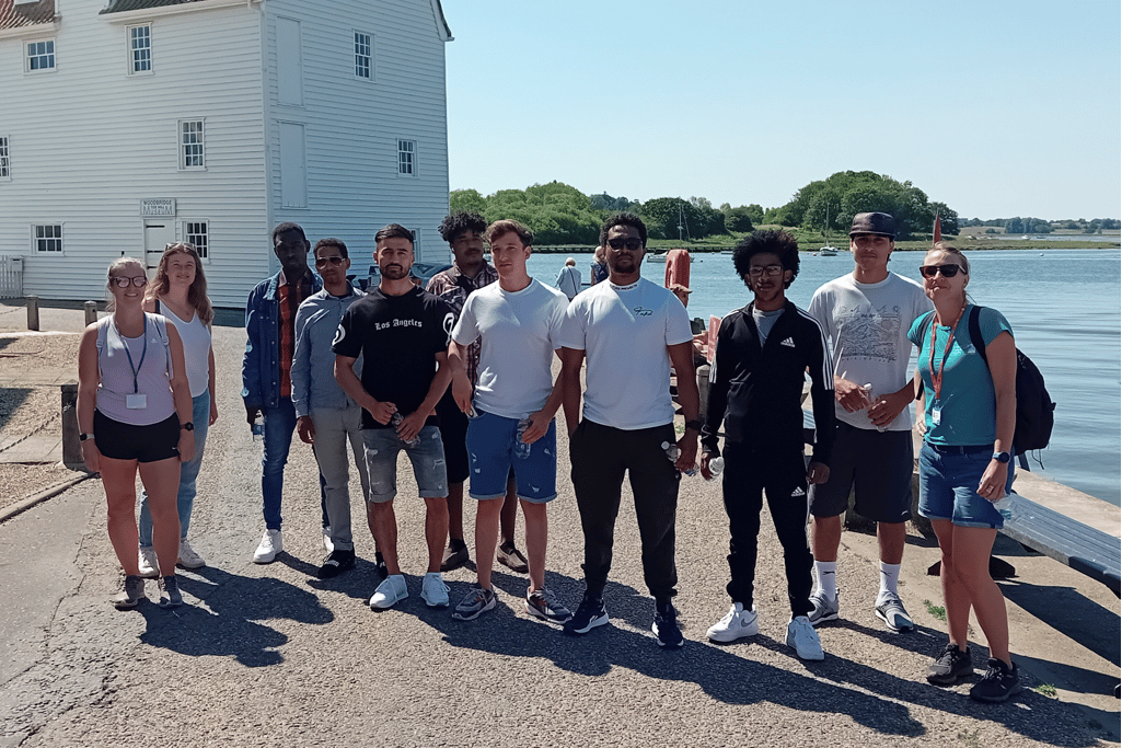
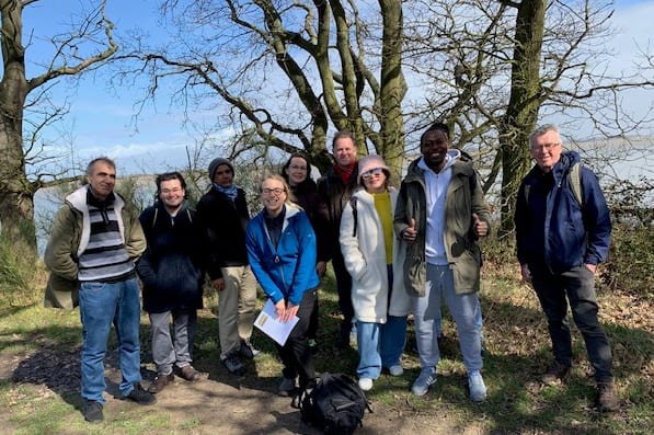
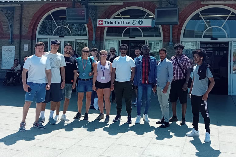
As part of the Coast & Heaths and Dedham Vale Areas of Outstanding Natural Beauty’s efforts to improve access to the natural environment, local organisations have partnered to launch several initiatives to ensure the landscape is for everyone.
The Landscapes for All work aims to use existing accessible public transport links to introduce under-represented communities to the countryside, including Ukrainian families, underprivileged women and children, and refugee groups.
Led by local experts, groups have walked from train stations on the edges of the Area of Outstanding Natural Beauty to some of the area’s most beloved locations, such as Wrabness, Flatford, and Woodbridge riverside.
Across the different walks that have taken place so far this year, more than 110 people have taken part, during which they have learnt about local wildlife, the landscape, and artists who have been inspired by it.
Organisations involved in the initiatives include Community Rail Partnership in Essex and South Suffolk and East Suffolk, Refugee, Asylum Seeker & Migrant Action (RAMA), Ipswich-based P.H.O.E.B.E., an Ipswich-based registered charity that supports black and ethnic minority women and children, as well as the Suffolk Refugee Support group, and The Fitzwilliam Museum in Cambridge.
Introducing different groups of people to the countryside can help develop knowledge of the local area and public transport links, build confidence, and provide the skills to explore Areas of Outstanding Natural Beauty independently. Essex County Council’s Path to Prosperity and Suffolk County Council’s Green Access team funded the initiatives.
“Today is good for me and it was an experience with new places to see. I was very happy mentally, walking together, walking along the river, thank you.” Participant from the Suffolk Refugee Support walk from Woodbridge to Melton.
“We firmly believe that our landscapes should be accessible to everyone. There are so many fantastic organisations working to support refugees and other vulnerable people in Suffolk and Essex, and we will continue to build partnerships that enable more people to experience the Areas of Outstanding Natural Beauty.” Jenny Moss, Landscapes for All Officer.
“These fantastic Landscapes for All Initiatives are empowering different groups of people to discover the natural environment and the associated benefits of being outdoors in our Areas of Outstanding Natural Beauty.” Coast & Heaths Area of Outstanding Natural Beauty Partnership Chairman, Nick Collinson.
“Partnership working is what Areas of Outstanding Natural Beauty do best, and it is brilliant to see different local organisations coming together to facilitate these initiatives, which will make our special landscapes even more accessible and welcoming for all parts of society.” Cllr James Finch, the acting Chairman of the Dedham Vale Area of Outstanding Natural Beauty.
“These initiatives are making a true contribution to society by helping more people discover the benefits of our green spaces. They are also helping to safeguard our railways by introducing people to the local public transport links and giving them the skills to confidently explore the area by rail.” Aaron Taffera, Chairman of East Suffolk Lines Community Rail Partnership.
Feedback from the groups has been very positive and more initiatives are planned for 2023 and beyond. For more information, please contact Landscapes for All Officer, Jenny Moss at [email protected].
Insect Morphology Guides
As part of Insect Week in June, the Field Studies Council (FSC) Biolinks project produced some brilliant insect morphology guides, free to download from their website. These valuable new resources will help beginners with insect identification and recording.
In 2022, the Royal Entomology Society awarded the Goodman Award Grant to the FSC BioLinks project to increase the promotion and awareness of insect recording. This grant enabled the creation of accessible insect morphology infographics that will help learners who are new to the topic.
BioLinks created ten infographics and an educational video, helping to advance the public’s understanding of insects. By introducing scientific terminology in a visually engaging manner, these resources act as a stepping stone for individuals who want to use insect identification keys. Plus, these valuable resources are accessible under a creative commons license, allowing learners to use them as indispensable reference materials while also enabling other organisations to incorporate them into teaching resources.
With 80 years of experience, the Field Studies Council have championed insects through research projects, developed insect identification guides and educated people through courses led by experts. They have a history of projects focussing on increasing invertebrate identification skills across the UK, the most recent of which was the recently concluded BioLinks project.
The BioLinks project boosted biodiversity skills and helped to expand the UK’s database of underappreciated invertebrate species. Funded by the FSC and the National Lottery Heritage Fund, BioLinks successfully equipped over 5,000 participants with the knowledge and tools to identify diverse species, including flies, beetles, bees, and butterflies.
By providing comprehensive training on identification techniques, BioLinks empowered countless individuals to delve into the fascinating world of invertebrates, enlightened learners and encouraged them to submit biological records. As a result, an impressive 35,000 invertebrate records have been generated!
The guides can be downloaded HERE
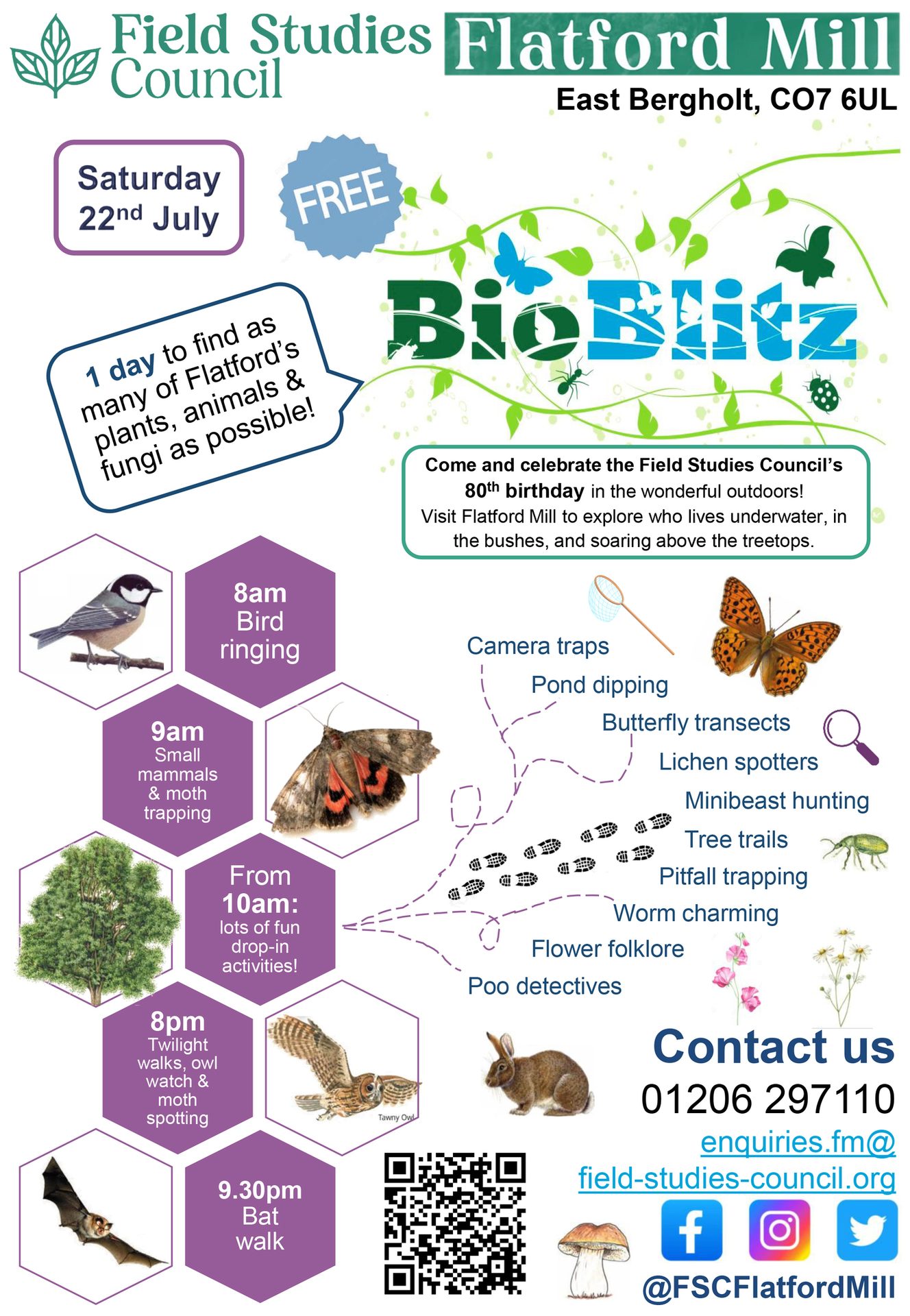
BioBlitz 2023 at FSC Flatford Mill
Irene Barriga Garcia-Lisbona,
Field Studies Council, Flatford Mill
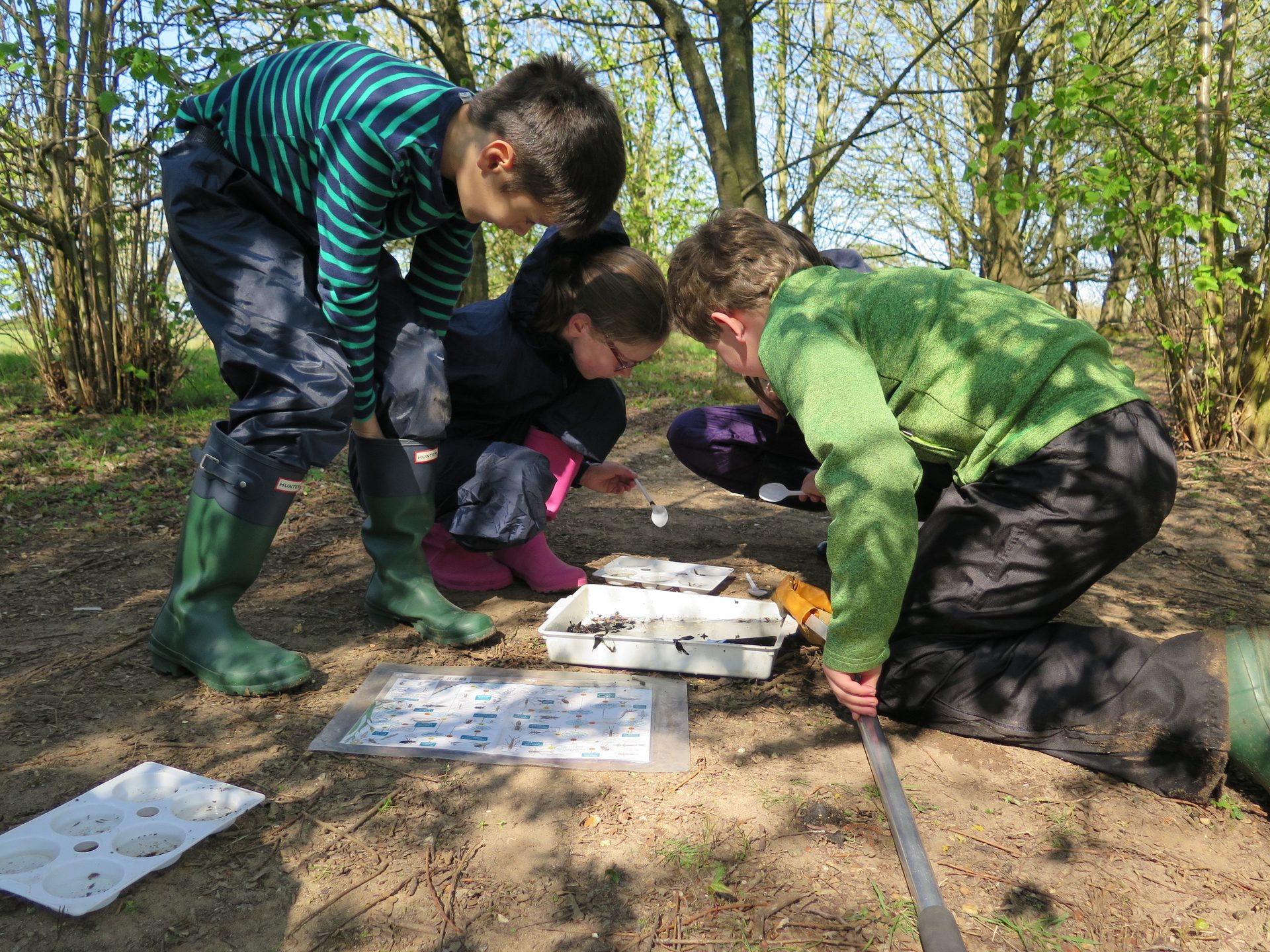
Calling all naturalists! Come on down to the Field Studies Council Centre at Flatford Mill on Saturday, 22nd July, to join in our annual BioBlitz event!
We hope to record as many species as possible in just one day across all our habitats on site. The BioBlitz is open to the public, and we welcome all ages and levels of expertise.
The day will run from 8 am – 10 pm, starting with bird ringing, mammal & moth trapping, and ending with evening walks to spot bats, owls, and night moths. Drop-in activities will be happening throughout the day, including pond dipping, camera traps, butterfly transects, invertebrate hunting, bird watching, tree trails, lichen detectives, pitfall trapping, flower folklore, tracks & signs spotting (poo detectives).
FSC Flatford Mill is a residential field centre in the historic Grade I-listed mill on the River Stour within the Dedham Vale AONB. Across our 25 acres, our grounds are home to a range of woodland, wetland and freshwater habitats, including mature and establishing trees, reedbeds and several ponds. We have recorded several BAP species onsite, including spotted flycatcher, pipistrelle, common cuckoo, and great crested newts.
At the BioBlitz, naturalists are welcome onsite to do surveys to add to our total count! We would be grateful if any volunteers could help verify ID and interact with members of the public during the drop-in activities. We are particularly interested in having specialists onsite for botanical ID; fungi; lichen; all insects, including butterflies & bees; tracks & signs. We can provide refreshments! Please get in touch with the centre at: [email protected] or call 01206 297110 if you will be joining the BioBlitz.
Looking forward to seeing you on 22nd July!
Restoring Suffolk’s Traditional Orchards
Tom Fairbrother, AONB
An exciting project to restore traditional Suffolk orchards is underway in the historic Sandlings area of the county.
Many of Suffolk’s traditional orchards have been lost over the past 100 years. Traditional orchards provide unique habitats to many bird, insect, and animal species, several of which wholly depend on the orchard. They also capture carbon, improve soil health, and help to reduce localised flooding.
For Years 1 and 2 of the Farming in Protected Landscapes programme, £57,226 was awarded to farmers in the East Suffolk Farmer Group to create 16 new orchards in the Sandlings area of south Suffolk.
The new orchards have been planted in different locations to connect with existing wildlife habitats, such as woodland and hedgerows. The orchards have a wide range of trees, some of which have become rare, including cobnut, walnut, and heritage fruit varieties.
The Farming in Protected Landscapes programme is funded by Defra and managed locally by the Coast & Heaths Area of Outstanding Natural Beauty team.
Nigel Chapman, Chair of the Farming in Protected Landscapes decision-making panel, commented: “The value of traditional orchards cannot be underestimated. They can support hundreds of species of plants, animals and fungi, they are a true sign of the seasons for us all, from spring blossoms to an array of autumn fruit, and they can help satisfy the demands of any ever-increasing market for seasonal and locally sourced produce.”
For the 2022-23 financial year, the Farming in Protected Landscapes programme supported the farming community with grants totalling £233,654 for 14 projects in the Coast & Heaths Area of Outstanding Natural Beauty.
We are delighted to confirm that additional funds are available for 2023/24 totalling £345,443. So far, around half of this fund has been committed to projects.
Due to its overwhelming success, the Farming in Protected Landscapes programme has been extended until March 2025, and the Coast & Heaths Area of Outstanding Natural Beauty team is inviting farmers and land managers to apply for a grant. Projects support nature recovery, mitigate the impacts of climate change, provide opportunities for people to discover, enjoy and understand the landscape and cultural heritage, or support nature-friendly, sustainable farm businesses.
For more information or to discuss a potential project, contact Farming in Protected Landscapes Officer, Alex Dinsdale, at 01502 674630 or email [email protected]
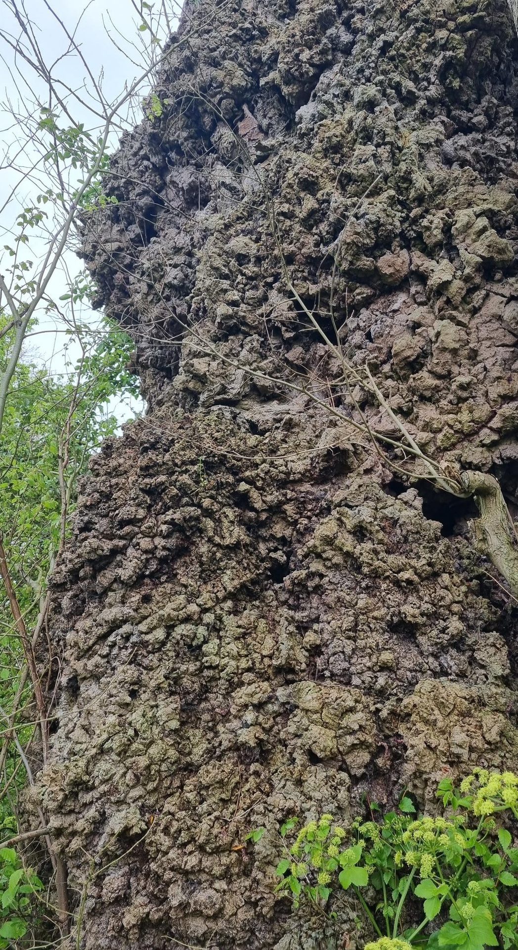
Magnificent veteran Native Black Poplar, Butley (growing on dry sandy soil!)
Native Black Poplar Project
David Appleton, Suffolk Tree Warden Network
Many articles have been written over the years about the Native Black Poplar (NBP) because of its rarity, the architectural beauty of mature specimens in the countryside, and its historical significance in recorded landscapes, along river banks and overhanging ponds, being a wetland species.
What appears to be a relatively strong and age-diverse population in Suffolk must in large part be due to the hard work of many people in recent decades since the NBP was championed by Edgar Milne-Redhead in the 1970s/’80s, not least by the tree’s County Recorder, Sue Hooton. Thanks to the diligent work of SBIS, Suffolk enjoys an extensive database of its NBP population.
The Suffolk Project
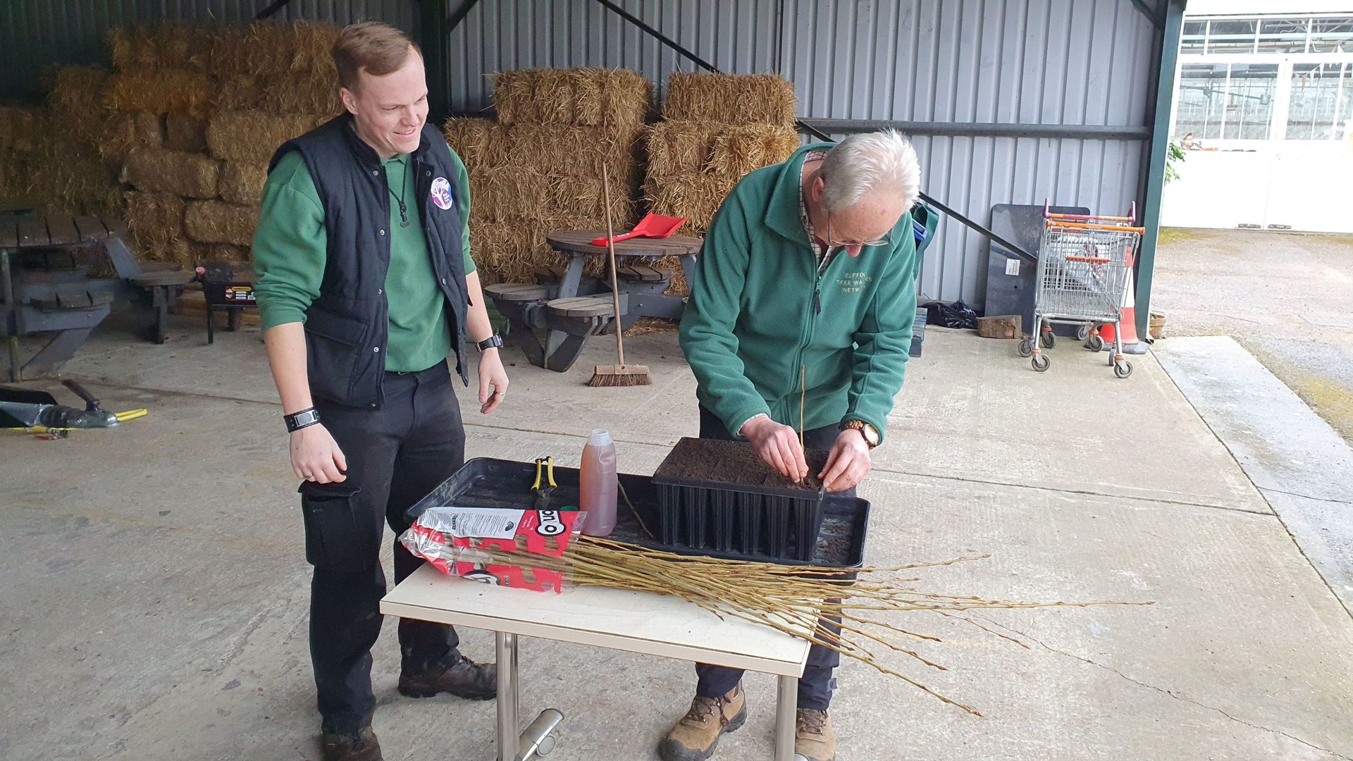
The Suffolk Tree Warden Network (STWN), therefore, enjoyed significant advantages when, 2 years ago, several of its members expressed interest in seeking to ensure the survival of this species in the Suffolk landscape, given that the conditions for its natural regeneration through viable seed are now rarely, if ever, found. As the project has developed, with the ongoing support of the County Recorder, SBIS and Gary Battell (Tree & Woodland Officer for Suffolk County Council), its objectives have developed and include (i) assisting in the management of the Dedham Vale AONB clone bank at Alphamstone, (ii) propagating an annual planting stock via cuttings from clone trees, (iii) distributing saplings via STWN and environmental groups such as the River Waveney Trust, Little Ouse Headwaters Project and the Suffolk AONBs, and (iv) updating the SBIS database by surveying known trees and recording newly-discovered trees.
Over 130 saplings (50% male, 50% female) were distributed from STWN*s nursery during the winter of 2022-23, in addition to those grown in the Dedham Vale clone bank nursery.
The project developed further in 2023, resulting in both Dedham Vale’s clone bank and STWN*s nurseries being moved to the Walled Garden at Nowton Park and the rejuvenation of Nowton Park*s clone bank (established when the Thrandeston clone bank was closed some years ago). Over 250 saplings are currently being grown at Nowton, both to re-stock the Nowton and Dedham Vale clone banks and provide planting stock for winter 2023-24: again, the male/female proportions are being kept equal, to ensure an increase in the numbers of the much rarer female.
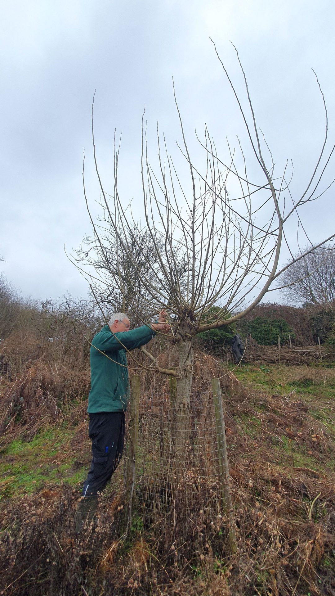
An important part of the project has been to ensure that the planting location and clone number of all new saplings are carefully recorded (with 10-digit grid references) so that these can be accurately recorded on the SBIS database. This has a dual benefit – enabling future generations to identify the location of specific clone trees if needed for propagation or research purposes and preventing the need for accurate identification/DNA testing by future surveyors (not always easy because NBPs readily hybridise). This recording process involves significant care and administration but is considered fundamental to the project’s success. In an ideal world, the location and clone number of all Suffolk NBPs will eventually be recorded.
The Otter Trust (based in Dickleburgh) began a similar project for Norfolk at much the same time as the STWN project, and a close working relationship has been developed, which led to the Otter Trust kindly funding the DNA testing of 20 selected Suffolk trees. At the time of writing, 15 mature Suffolk trees have been tested by Forest Research, identifying the clone number of 14 (and identifying one as a hybrid): these data have been used to update the SBIS database. The remaining 5 trees will be tested in the coming weeks. Excitingly, the survey project has discovered several mature trees previously unrecorded on the SBIS database – although no new clones have yet been found.
Links have also been forged with staff at Wakehurst who manage the clone bank and nursery for the Sussex Black Poplar Partnership; with a developing Essex project, in which the Otter Trust plays a key role; and a Herefordshire project. Consideration is being given to reestablishing regular meetings with these and other NBP groups to coordinate conservation efforts.
Propagation Techniques
The Wakehurst NBP nursery comprises a cultivated nursery bed in which bare root cuttings are grown. The Dedham Vale nursery was a field-based bare root nursery, with cuttings pushed into the ground through slits in weed suppressant fabric. NBP cuttings tend to develop long roots very quickly once they strike, so both these methods have their advantages (e.g., allowing unrestricted root development) and their disadvantages (a nursery bed requires significant human resources in cultivation and management; a field-based nursery can suffer weed and drought problems; both methods are likely to result in significant root loss when saplings are transplanted). In Herefordshire, long ‘truncheons’ (thick cuttings) are pushed into the ground in their planting location (which has obvious advantages and disadvantages). The saplings at Nowton are container-grown, which facilitates management and movement to the plant site, but does result in some restriction in root growth. For this reason, cuttings are planted out in Year 1. However, we are actively considering how to improve this process to produce the best quality planting stock to maximise survival and growth rates.
Genome Analysis
In recent weeks, we have had the opportunity to participate in a Europe-wide project to map Black Poplar genomics, funded by the University of Udine, Italy, with testing conducted by Professor Michele Morgante, who has developed a whole genome SNP (Single-Nucleotide Polymorphisms) survey method to create a database of continental European populations, to which UK populations can be compared. This opportunity grew from an initial collaboration between the University of Udine and Eastbrookend Country Park, the Thames21 healthy rivers project and Thames Chase Community Forest, all of which are planting new NBP populations.
A total of ten samples have now been taken from Norfolk clones and thirteen samples from Suffolk clones, by Heidi Hauffe, Senior Researcher at the Conservation Genomics Research Unit, Fondazione Edmund Mach in Italy, with a further five samples being collected from additional Suffolk trees. These samples will be sent to Udine for testing. They will give a more detailed insight into Black Poplar genomics than available from the more restricted testing commissioned from Forest Research. This may lead to much greater knowledge of the East Anglian NBP population and its relationship to continental European populations.
The Future
The Suffolk NBP project is at an exciting stage. The Suffolk trees survey programme will continue to bring the SBIS database as far up to date as possible. However, surveying relies entirely on volunteers, as is much of the nursery propagation project. The initial funding from Suffolk County Council’s 2021 Fund for the STWN nurseries has expired, and new funds must be obtained to provide essential materials. Securing core funding to support the project’s key objectives would accelerate its significant achievements.
Thanks to Emma Black and volunteers, Dedham Vale AONB; Liam Judd and volunteers, Nowton Park; Ben Potterton of the Otter Trust; Suffolk Tree Wardens and other survey volunteers who have supported the project.
Can you help the Green Light Trust?
Danny Thorrington, Green Light Trust
Hi, I am introducing Green Light Trust to you all and explaining what we do and how you can support our work.
Who we are
Green Light Trust is a well-established and successful environmental and well-being charity. We support people from all backgrounds to rebuild, reawaken and refocus their lives by enabling access to natural spaces, positively impacting their mental health. We believe in the power of Green Care – the idea that the environment is an advantageous tool in the care of us all in society. We have access to several sites across Suffolk and Norfolk, including Lawshall (Frithy Wood and the Foundry), Martlesham (Castan Wood), as well as operating out of RSPB Minsmere, Sotterley Hall, West Stow Country Park and Trinity Park Ipswich.
Our Founders
The story of Green Light Trust spreads far beyond the shores of Suffolk and far deeper than the wild woodlands we now manage in the heart of our much-loved county.
In fact, the journey began in 1988, when the inspirational and nature-loving pairing of Ric Edelman and Nigel Hughes visited the Hunstein Range Forest, deep in the Upper Sepik region of Papua New Guinea. It was as part of their trip, meeting tribe folk, recognising the power of forest preservation activity on communities and being somewhat ‘challenged’ to take this centuries-old attitude of care for the environment back to British turf, that the Trust’s early seeds were first sown.
During their time there, they learned how the ecosystem of 2000 square miles of pristine forest was to be lost to logging, so they worked with the local people to help them save their homeland. What followed was a call to arms from the tribe, wondering why they wouldn’t also want to do something back in the UK to preserve woodland and wild spaces for future generations.
Inspired, they returned to the UK and established Green Light in 1989 as an environmental charity based at Lawshall. Their goal was to educate and inform the UK public on environmental matters. What they established snowballed. In 1993 a small group of people living in Lawshall created their own woodland. This became known as ‘Forest for Our Children’ and started life in a two-acre field, with the first trees planted by the Chief of the tribe Ric and Nigel had met on their travels. Today, we are proud and delighted that this vision has grown with over 60 community woodlands established and some 6 million trees planted.
What we do
From these roots, Green Light Trust now work alongside participants of all ages and takes them from their ‘normal’ environment, with their usual environmental cues, and introduces them to a woodland space where they can start to develop positive change. Our woodland environment is rich with inspiration and resources, which we use to immerse attendants in activities that develop physical, social and emotional skills.
Our courses are aimed at adults, children and young people who have experienced issues that impact their mental health, including victims of violence, trauma or abuse. We also work with participants who have complex additional support needs. For example, they may have an Educational Health Care Plan, be experiencing social and emotional behavioural challenges, have neurodiverse conditions, have a history of offending or might be in recovery from substance or alcohol misuse.
Benefits for the participants include improved mental and physical well-being, increased confidence and self-esteem, reduced anxiety and social isolation, improved social and communication skills, new practical and life skills, and an appreciation and knowledge of the natural environment.
We believe everyone should have equitable access to the power of nature
A lot of those we help won’t usually have access to the green space we bring them into, so getting them involved in appropriate woodland management tasks such as green woodworking, campfire cooking, natural crafts and nature connection and conservation activities really helps them to explore and benefit from an environment which is often new to them. Our nature-based courses use the power of nature to build resilience and resourcefulness in participants, giving them the skills they need to immerse themselves back into society and deal with day-to-day life, ultimately minimising their reliance on the NHS and public services.
Our Learning Environment
The natural environment provides the perfect space for individual personal growth; the woods’ natural rhythm enables learners’ minds to slow down to match it.
We work together on tasks that are mindful, purposeful and fun. Tasks where learners can allow their creativity to come to the fore. It is an environment that helps reaffirm that we are part of nature, not separate from it. The natural environment is also excellent for building resilience in our learners, being outside in all weathers and still enjoying our days.
The woodland environment allows learners to do things they didn’t know they were capable of, boosting their confidence as they start to succeed. Once this process begins, the possibilities open up in front of them and with the support needed, they can have the courage to take them.
So, how can you play a vital part?
We are committed to our work supporting people within a natural environment. However, we are also aware that we are just custodians of the beautiful sites in which we work. As part of our ongoing woodland management and conservation activities across our sites, we need to look after them.
We carry out coppicing and aim to improve the bio-diversity of the woodlands where we work, creating opportunities for new habitats to nurture a broader range of species across our sites. Our management aims to bring a more varied age structure to the woodlands and create varying light levels that boost flora and fauna at these locations. To evidence this, we want to survey and record the flora and fauna at our sites and call upon anyone happy to share their knowledge and experience in helping us achieve this.
With your help, we hope to upskill staff and participants to continue monitoring our impact and enhance our treasured sites so that they continue to benefit both humans and nature.
If you are interested in helping us by volunteering your expertise, please get in touch with Danny Thorrington by emailing [email protected]
Before (left) and after (right) clearing invasive species
Restoring ancient woodlands in the Stour Valley
Tom Fairbrother, AONB
An exciting project to restore an ancient woodland in the Stour Valley is underway in a bid to boost diversity and conserve the character of the local environment.
For Years 2 and 3 of the Farming in Protected Landscapes programme, £22,636 has been awarded to Rivers Hall Farm Estate for ancient woodland restoration.
Ancient woodland is one of the richest and most diverse habitats we have, encompassing soils, fungi, plants, and animals. However, many ancient woodlands are in decline due to a historical lack of appropriate management or neglect.
At Rivers Hall, rhododendron and bamboo had been introduced as game shooting cover, but both species had become invasive and dominated the ancient woodland understorey. As part of the project, the first year will see the invasive species physically removed to create space and light to allow natural tree regeneration.
In year two, 1,000 young native trees and shrubs will be planted. Children from the local primary school, which already uses the farm and woods for its forest school classes, will help plant the new trees.
The Farming in Protected Landscapes programme is funded by Defra and managed locally by the Dedham Vale Area of Outstanding Natural Beauty team.
Nigel Chapman, Chair of the Farming in Protected Landscapes decision-making panel, commented: “The Panel particularly welcomed the participation of local school children in this project. It is vital that the next generation is closely involved in this restorative work today and, thereby, become the proud guardians of these incredibly special places in the future.”
For the 2022-23 financial year, the Farming in Protected Landscapes programme supported the farming community with grants totalling £114,245 for projects in the Dedham Vale Area of Outstanding Natural Beauty and Stour Valley.
We are delighted to confirm that additional funds are available for 2023/24 totalling £183,463. Due to its overwhelming success, the Farming in Protected Landscapes programme has been extended until March 2025, and the Dedham Vale Area of Outstanding Natural Beauty team is inviting farmers and land managers to apply for a grant.
Projects support nature recovery, mitigate the impacts of climate change, provide opportunities for people to discover, enjoy and understand the landscape and cultural heritage, or support nature-friendly, sustainable farm businesses.
For more information or to discuss a potential project, contact Farming in Protected Landscapes Officer, Alex Dinsdale, at 01502 674630 or email [email protected]
© tomline43, Flickr
Re-Mapping Newbourne Springs Nature Reserve
Dr Adrian Cooper
Felixstowe’s Citizen Science Group’s (FCSG) re-mapping project challenges the data types employed within map making. The group decided to use Newbourne Springs Nature Reserve as a case study because it is a significant place for all members.
Maps are an attempt to represent an environment, landscape or place. They are the product of interactions between the map makers’ imaginations and the objectivity of the area under consideration. Those interactions become problematic when we recognise that people respond to their surroundings differently. For example, some map makers may show boundaries and routes in their work. Others may prefer to identify economic resources. The forms in which maps may appear are almost endless.
This re-mapping project attempts to represent Newbourne Springs Nature Reserve in ways which are important to FCSG members. People are encouraged to use the resulting maps alongside existing ones, such as those created by the Suffolk Wildlife Trust. This re-mapping project does not criticise them but presents an alternative view of the area.
The group discussed their planned method of re-mapping Newbourne Springs throughout May. On 1 June, all members attended a walk at the Nature Reserve, using various paths across the area. During the walk, members noted features they wanted to include in the re-mapping project. Artists sketched landscapes and wildlife, creative writers recorded individual words and lines of poetry, and musicians composed melodies in response to their experiences. Those members with children were encouraged to take them for the walk, and the children were encouraged to share what they felt was significant about the Nature Reserve. Over the next few days, members repeated the walk either alone or in smaller groups.
On 8 June, the group organised a second walk that 33 members and some of their children attended. Members returned from the walk with more notes, poetry, prose, sketches, photographs, sound recordings, ideas and memories.
This re-mapping project appreciates the importance of walking to engage thoughtfully with an environment. Walking, therefore, identifies the value of personal geographies, which embody ways of thinking and responding to an environment which is the product of independent thought and creativity. Personal geographies are not passive. They are active and continually changing and connect people with places. Personal geographies are often confronted, contested and marginalised by other ways of seeing and responding to an area. However, a core belief within this re-mapping project holds that democratised geographies (i.e. geographies of independent thinkers) should find a place alongside mainstream maps.
Another key feature of this re-mapping project is that it emphasises group members’ experiences of place rather than their judgements. That is, while judgements about a location imply a sense of finality in their conclusions, their focus on experiences shows personal geographies as works in progress: constantly evolving and developing.
Following the second walk, group members met to develop a high-level Newbourne Springs Nature Reserve map. Resulting in Map 1, shown below.
This map locates Newbourne Springs Nature Reserve using conventional referencing (see central panel). In the lower right section, the Conclusions panel identifies three areas the group can develop in future iterations of this work. However, the map’s main feature is its inclusion of multi-sensual data. That is, data drawn from visual, aural, taste, touch and fragrances. Regarding visual and scent data, the panels on the right-hand side of the map suggest possible ways to express and share them. Future iterations of this work might identify other methods, such as modern dance, filmed and attached to the map as mp4 files.
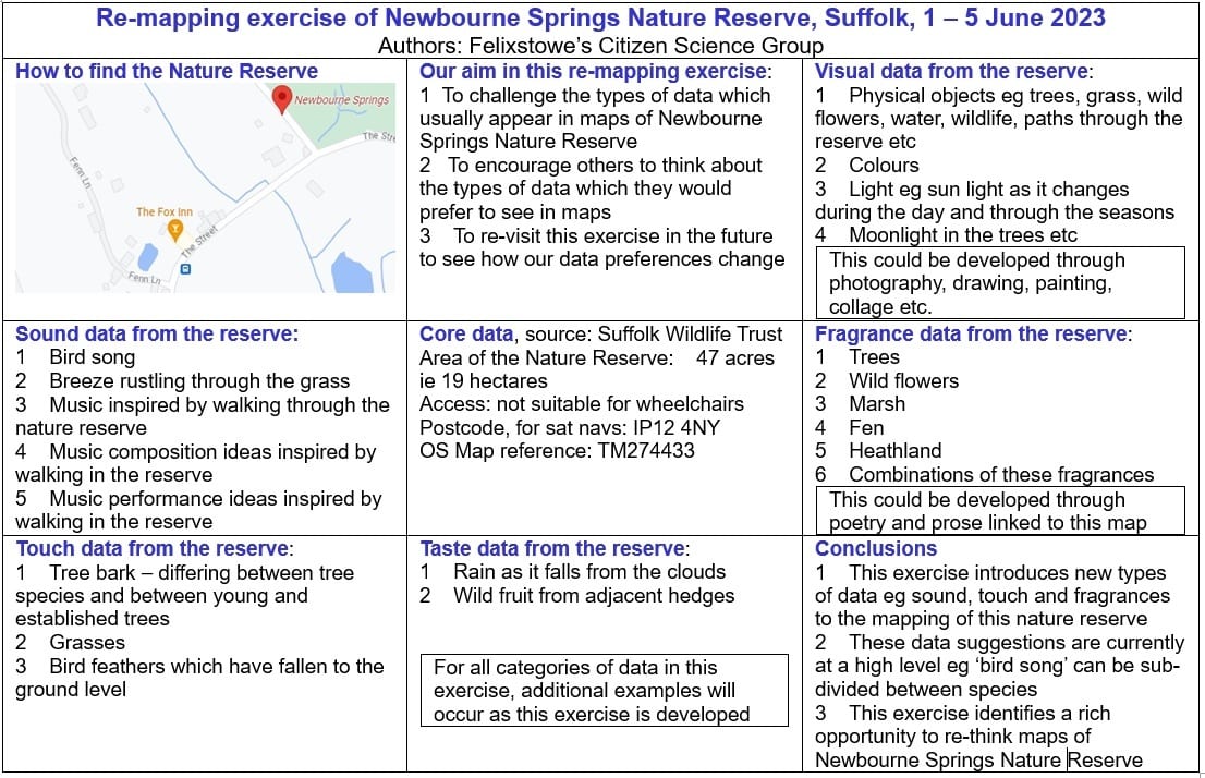
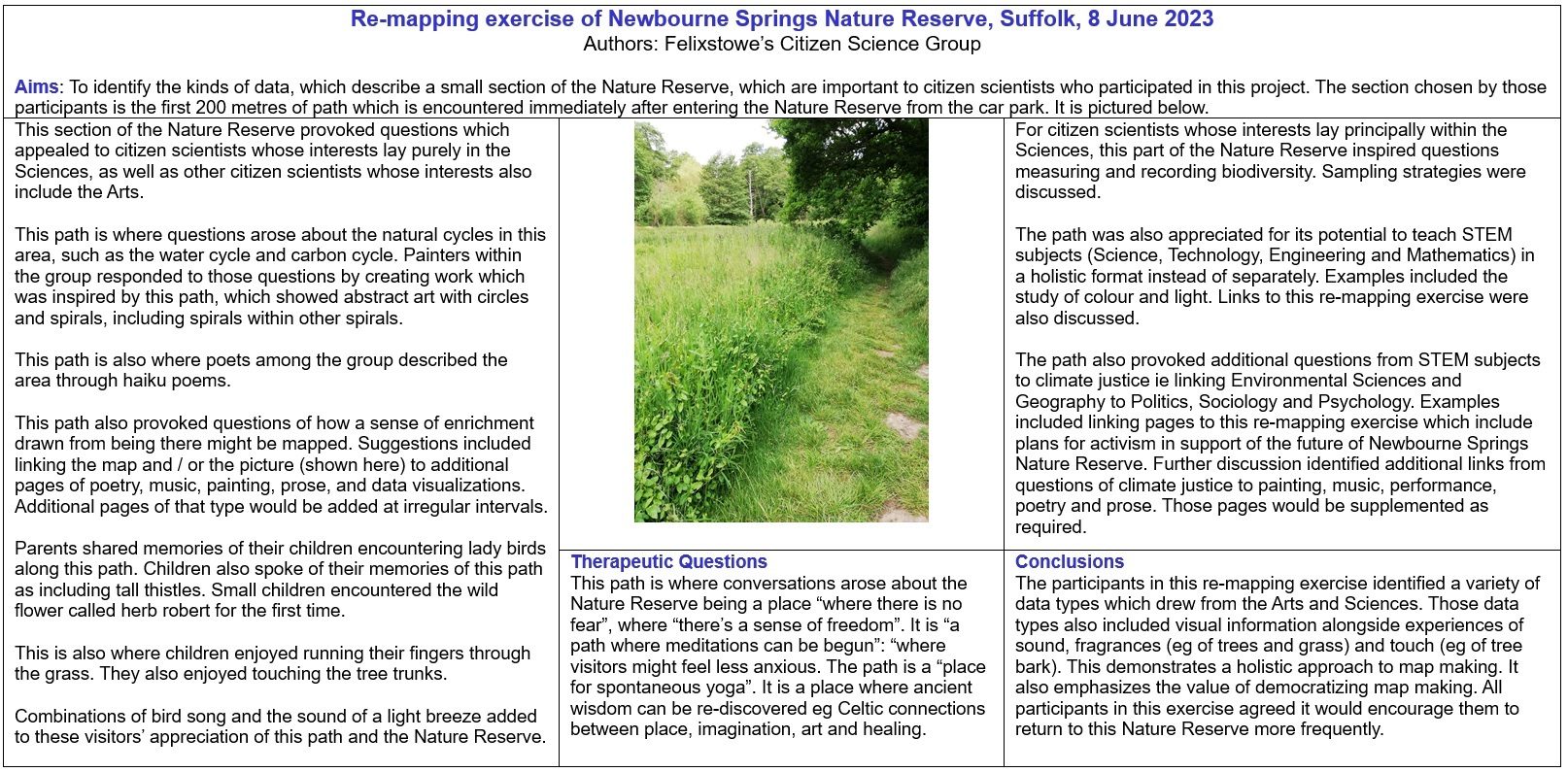
In response to the first map, the next iteration was to reduce the map scale from the whole of the Nature Reserve to just a 200-metre path length to experiment with the potential of this approach to re-mapping. We show the results of the micro-scale re-mapping in Map 2.
Once again, it includes multi-sensual data and identifies therapeutic questions in the map’s lower central panel. The group discovered that children found identifying the smaller area’s key features easier. Having identified those therapeutic features of the Newbourne Springs Nature Reserve path, the group fed them back into the first map.
In developing the two maps, group members sometimes disagreed on what should be included and excluded, so there was a group vote to decide.
Members also found themselves surprised by parts of the final maps. For example, those from a purely scientific background found themselves approving of the multi-sensual data, even though none had previously worked with those data types. They also found themselves surprised at the inclusion of therapeutic questions and references to ancient wisdom. However, they recognised that those data types were consistent with a re-mapping project created by a mixed group of citizen scientists.
Members agree there is more to do in re-mapping Newbourne Springs Nature Reserve. They also wish to encourage other groups to re-map locations that are significant to them and hope there will be a cross-fertilisation of ideas between groups who engage in these projects.
Future iterations of the re-mapping project must improve inclusiveness. They will contact others in the Felixstowe area and request their input on future maps, and work
has already started on a collaboration with the Chill Yard youth project in Felixstowe.
The group has identified three regions of inclusiveness:
- More people of diverse religious faith
- More women
- More young people, i.e. people up to the age of 25
Group members note that people in Felixstowe do not wish to be categorised by their skin colour. Instead, they prefer attributes of faith, gender and age. In other regions, inclusiveness will need to be tailored to local preferences.
Felixstowe’s Citizen Science Group members drew great value from a wide range of work while developing this re-mapping project. Wildlife in the Anthropocene by Jamie Lorimer showed that ideas about nature and environments always reflect cultural histories. In Prismatic Ecology, edited by Jeffrey Jerome Cohen, the group discovered that they should not reduce responses to landscape and place to purely “green” readings. Cohen and his contributors also demonstrate that notions and representations of ecologies are often more complex and disordered than previously assumed. Finally, in The Good Natured Feminist by Catriona Sandilands, she encourages conversations between eco-feminism and radical Geography, discussions between Ecology, Geography and identity politics, and activism arising from those debates.
The group drew five conclusions from their discussion:
- The re-mapping of Newbourne Springs Nature Reserve by FCSG will supplement other maps without criticising or replacing them.
- The re-mapping of Newbourne Springs Nature Reserve by FCSG has identified significant data types, such as the multi-sensual data and therapeutic questions, which they can explore further.
- Data Management questions are fundamental to this re-mapping project and will remain on the agenda for all future iterations.
- Innovation is also essential to this re-mapping project, and fresh ideas will be encouraged at each member’s meeting.
- Inclusiveness will be fundamental to the innovation process. FCSG recognises the added richness of inputs will lead to enhanced data-rich maps in the future.
Ultimately, the group hopes its re-mapping project will encourage other groups to engage in re-mapping work. They welcome constructive feedback through their Facebook page.
New Habitat Surveying Courses
The Field Studies Council has recently released some new courses which focus on habitat surveying and the use of UKHab.
Habitat Survey Courses
Courses are run at all levels, starting with becoming more biodiversity aware, to Phase 1 and UKHAB training courses. The courses are delivered by experts in the field, and will equip you with the skills and knowledge to discover more about surveying habitats, botany skills for surveying and the metrics used within habitat surveys. The beginner courses are for anyone, and the more advanced courses cover more in depth skills and understanding, offering the chance to practice and hone your skills, supervised by experts.
These courses cover broad issues of ecology and conservation including:
- Ecological principles
- Biological recording
- Biological surveying
- Higher level species identification
- Habitat overviews
- Habitat management
- National Vegetation Classification
They are led by expert tutors who are passionate about the subject. Taking place at venues across the UK, or online, the FSC courses are designed to progress your learning at a level to suit your needs.
Each course is part of a learning framework and are available at all levels from beginner through to professional training.
If you're new to the topic, the Introduction to UK Habitat Surveys is a good place to start.
The intermediate 2-day course Surveying Habitats using UKHab will help you upskill and build on existing knowledge, with a particular focus on the UKHab classification.
Other courses include
- Biodiversity Skills: Animal Monitoring and Management
Duration: 1 day
Level: Beginner - NVC: Grasslands - MMU
Duration: 4 days
Level: Intermediate - NVC: Winter Habitat Survey - Understanding and Describing Plant Communities
Duration: 2 days
Level: Intermediate - Phase 1 Survey with Plant Identification Focus
Duration: 2 days
Level: Intermediate - Site Assessment Using Vegetation
Duration: 4 days
Level: Intermediate
Are you currently studying? If so, students can get 20% off these courses using the code BIOSTUDENT20 at checkout.
Learn more on the FSC website
Orange-vented Mason Bee, © Paul Kitchener, Flickr
£1 Million in match funding available to protect and restore nature
Aviva, in partnership with the Royal Society for the Protection of Birds (RSPB) and World Wide Fund for Nature (WWF), is making £1 million in funding available to support community groups across the UK to protect and restore nature in their local area.
The Save Our Wild Isles Community Fund is a crowdfunding initiative that will give £2 for every £1 raised by each project. The matching applies to each donation up to £250, with a total of £5,000 in match funding available per community project. A wide range of nature projects can be supported, from creating community gardens and replanting wildlife meadows to protecting wildlife and promoting community connection to nature. Applications can be made at any time until all funding has been allocated.
Applications are now open
To apply your project needs to be focused on taking action for nature in one of the following three ways:
1. Nature restoration – boosting local biodiversity by protecting or restoring habitats, creating space for nature, connecting green spaces and/or addressing activities that directly impact biodiversity.
2. Nature connectedness and pro-environmental behaviours – supporting greater connection to nature and promoting pro-environmental behaviours at the community level that will benefit nature.
3. Community cohesion and connection – a nature-positive activity that encourages collaboration in the local community by connecting people of diverse backgrounds, generations, and abilities to nature and one another.
More information and how to apply can be found on the Save Our Wild Isles website
JNCC would love to hear your thoughts on habitat recording!
Habitat information is important for conservation, and the Joint Nature Conservation Committee (JNCC) would like to explore the feasibility of increasing the amount of it collected by you, as volunteer citizen scientists.
They would very much appreciate if you are happy to contribute your thoughts on habitat recording through these two surveys to help JNCC to design interesting and useful solutions for recording habitat. Please note that the surveys will close to new responses on 31 July 2023.
The first survey will help JNCC to understand perceptions about recording habitat information. It should take no longer than 10 minutes to complete. You must be aged 18 or over and based in the UK.
The second survey aims to understand the user-friendliness of a new app for recording habitat data – EarthTrack – which is one of several options being explored to help volunteers collect habitat data in the UK. You will need to download and test the app before you can fill in the survey (see instructions at the start of the survey itself). Testing the EarthTrack app should take no longer than 5 minutes once you are in your chosen location with the app downloaded, and have GPS signal. Filling in the survey should take no longer than 5 minutes. You must be aged 18 or over, but can be based anywhere in the world.
© Events Jess Bailey, Unsplash
Events
Conferences, Webinars and Training
Suffolk Naturalists’ Society 2023 events
Field trip to SWT Lackford Lakes • 15 July
Field trip to RSPB Havergate Island • 19 Aug
email [email protected] for full details
Suffolk Wildlife Trust
- Wild Walk: Bird I.D • 12 Jul • Lackford Lakes Nature Reserve
- Evening wildlife walk • 14, 21 & 28 Jul • Various locations, East Suffolk
- Butterflies in Bonny Wood • 15 Jul • Bonny Wood Nature Reserve
- Wildlife Open Garden at Priors Oak • 16 Jul • Priors Oak, Aldeburgh
- Butterfly walk • 18 Jul • Bradfield Woods National Nature Reserve
- Field Sketchbook workshop SUMMER • 29–31 Jul • Carlton Marshes
- Wild Walk: Bird I.D • 29 Jul • Lackford Lakes Nature Reserve
- HOORAY for Heaths • 30 Jul • Knettishall Heath Nature Reserve
- Butterfly walk • 3 Aug • Bradfield Woods National Nature Reserve
- Wild Walks at dusk • 3 Aug • Knettishall Heath Nature Reserve
- Evening wildlife walks • 4, 11, 18 & 25 Aug • East Suffolk
- Wild Walk • 9 Aug • Lackford Lakes Nature Reserve
- Late Summer Bird ID • 13 Aug • Lackford Lakes Nature Reserve
- Summer Tree ID • 19 Aug • Foxburrow Nature Reserve, Woodbridge
- Summer Tree ID • 20 Aug • Redgrave & Lopham Fen Nature Reserve
- Wild Walks: ponies • 25 Aug • Knettishall Heath Nature Reserve
- Wild Walk: Bird I.D • 26 Aug • Lackford Lakes Nature Reserve
- Wildlife walk Woodbridge to Martlesham Creek and return • 26 Aug
- Eco Fair Lackford Lakes • 2 Sept • Lackford Lakes Nature Reserve
- Meadow management • 14 Sept • Moat House, Eye
- Your Community’s habitat • 20 Sept • Creeting St Mary Jubilee Hall
- A Beaver’s Tale • 20 Sept • Lackford Lakes Nature Reserve
- Hedges for Wildlife • 23 Sept • Foxburrow Nature Reserve
- Woodland Management • 4 Oct • Bradfield Woods Nature Reserve
- Colour photography • 7 Oct • Redgrave & Lopham Fen Nature Reserve
- Community Trees for Wildlife • 12 Oct • Thornham Walks
- Introduction to hedgehogs • 14 Oct • Foxburrow Nature Reserve
- Turtle dove conservation • 18 Oct • Lackford Lakes Nature Reserve
- Woodland Management • 21 Oct • Bradfield Woods Nature Reserve
- Wildlife Live Webinar - Recording, monitoring, surveying • 1 Nov • Online event
Full details and other SWT events
Field Studies Council
Natural History Courses
Covering all aspects of the natural world for beginners, enthusiasts, volunteer recorders and professionals.
Professional Development for Ecologists and Conservationists
An extensive range of courses that cater to a range of career levels, providing wildlife identification and surveying courses in many subjects.
Mammal Society Conference
4–6 Aug • Nottingham Trent University • The theme of this year’s Mammal Society Annual Conference is The Future of Conservation.
The Species Recovery Trust
Online courses
- Around Britain in 30 Bryophytes
- Around Britain in 20 Rushes
- Around Britain in 25 grasses
- Grasses Part 2
- How to survey & assess hedgerows
- Woodlands - Botanical Survey
- UK Habitat Classification
- Aquatic Plant ID
- Heathlands and acid grassland - Species and habitat survey
London Natural History Society
- Nature Recovery in London • 14 Sep
Royal Entomological Society
- Ento23 • 5-7 Sep • Hybrid Event
- Sustainable Agriculture: From monitoring to management • 27 Sep
- Online talk • 4 Oct
- XII European Congress of Entomology (ECE) 2023 – 16–20 Oct
- Online talk • 1 Nov
- Orthoptera Special Interest Group (SIG) 2023 • 8 Nov
National Biodiversity Network
RSK Webinars
The First Thursday Club is a monthly scientific, specialist-led webinar, on best practices relating to the natural environment.